SHELL
Brief History
Shell was established in 1897 and is still the largest brand of petrol in Europe, with over 10% of the market and the only company with a presence in most main retail markets, although sometimes through franchisees. Shell companies were 40:60 owned by Britain's Shell Transport & Trading and the Netherlands' Royal Dutch from 1907 until 2005. As Shell's history is well documented, (eg. in A Century in Oil, published by Weidenfeld & Nicholson in London in 1997) this web site will concentrate on the maps themselves.
There are many Shell maps shown here, with the approximate number of images shown in brackets (parenthesis), so they will be split into the following pages:
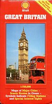
Above right Of Europe, but not from Europe. A 1985 Mairs map of Great Britain repackaged for the US market by Prentice-Hall, Inc of New Jersey. The use of the Shell pecten is surprising, although the hackneyed photo cover of Big Ben and a London bus is not! The flash in the corner "Scale 25% Larger Than Other Maps" indicating a scale of 1:750,000 rather than the supposedly more common 1:1,000,000 is understandable hype, but fails to mention that UK domestic Shell maps were at the much larger scale of 1:200,000.
As well as Shell maps on this site, there is a 1979 Shell Guide to Good Mileage.
Navigation: Following the next page link will take you through the sixteen pages listed above in order. The images shown are only a selection of Shell group maps issued over the past century.
Text and layout © Ian Byrne, 2000-20
All original copyrights in logos and map extracts and images are acknowledged and images are included on this site for identification purposes only.


