 SHELL
SHELL
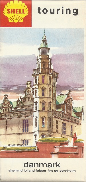
Road Maps of Denmark
Shell maps from Denmark offer one of the most continuous sequences of maps from any brand in any country. Shell's operations in the country started in 1913 with the formation of A/S Dansk Engelsk Benzin & Petroleums Co., although no maps are known from the company for its first 20 years of operation.
1930s maps

|

|
The oldest Shell maps of Denmark date from the 1930s and were issued by A/S Dansk-Engelsk Benzin & Petroleums Co. using cartography by the Geodætisk Institut in Copenhagen. |
 |
The hardcover atlas (above left) is dated 1933 and is similar in concept to the post-war one shown below. It has 5 pages of fold out maps at 1:580,000, and simple black and white town plans, overprinted with the main through routes in red. Additionally it has two period advertisements including the one for "Shell" Benzin & Smøreolie The Quick Starting Pair (in English) shown here. The 1938 Shell map of Denmark (right) uses the Foldex system, dividing the map into two sheets, pasted into a red card cover (and to each other). The main maps are at the commonly used Danish scale of 1:505,000 (~8miles to the inch) with a larger scale inset of the area around Köbenhavn, as it was still known.
1940s maps
 |
A/S Dansk Shell (as it had become) issued this hardback atlas in 1947. With similar cartography to the 1938 sheet map at the same scale, it contained 6 sheets that folded out of the book, and each had town plans on the reverse, now printed in four colours. |
 |
Ringsted, Roskilde and Rudkøbing can be seen on the page scanned and in all there were some 88 town plans included. At the back of the atlas there were 32 pages of text with historical notes on 199 stately homes and castles. In some ways it is remarkable that Shell was able to continue to publish its atlases so soon after the ending of the war, as its Head Office (the Shell-Huset) in Copenhagen was destroyed by German bombing in March 1945.
1950s maps
 |
 |
 |
 |
 |
The first two images are of an undated map that comes from around from around 1954. It uses the standard Shell style but with a more graphic rear cover: it is printed on a high gloss paper by Winther & Winther using IS Jensens cartography. The next map has a design first used in the late 1950s, with the Shell touring logo; it included drawings of characters in local costume above and below the map, and was produced by the same the same team but at the smaller scale of 1:570,000. This map mentioned the existence of separate city maps for Aalborg, Århus, Odense and København, as well as an area map of Nordsjælland. The four city maps had photographic covers of local scenes, except for Odense which featured a collection of objects associated with Hans Christian Andersen and unlike the smaller-scale maps, marked Shell stations with a conventional triangle. As all five additional maps were at a relatively large scale (ranging from 1:23,000 in Aalborg to 1:300,000 for the area map) they had to pay the Kort Stempel map tax. The yellow background on the area map suggests that it was probably first distributed a year or two later than the city maps shown.
1960s maps
 |
 |
The two maps on the left are estimated to date from 1961 and 1963 and the older is essentially the same as the ca1958 issue above. The 1963 map used a brighter coloured sea and replaced a mileage map and table with a camping map on the reverse. |
 |
 |
The near right map above, from 1964 or 5, is quite different. JS Jensens provided a map of Denmark at 1:510,000 on both sides, identical in every respect except the colours of main roads. On one side, the main routes (hovedveje) are red. On the reverse they are grey and selected secondary routes (parallelveje) are red; this side also shows scenic routes in blue. The later map shows that Shell had started a series of 5 regional maps covering the country: two for Jylland (Jutland), one for the islands, one for Copenhagen and - surprisingly - one for the Baltic island of Bornholm. This was however a period of growth for Shell, as it had commissioned its refinery at Fredericia in 1966.
The far right map is a sectional map, possibly dating from 1969. By then Shell had just three sections, with no.1 (shown) covering Zealand, Funen & Bornholm. Drawn at the larger scale of 1:320,000 by JS Jensens, and so subject to the Kort Stempel tax, it was backed by basic plans of 9 towns, marking Shell service stations.
1970s and 80s maps
 |
At a scale of 1:1,000,000, the map on the left is a German Mairs production from 1972 sold widely across Europe. Danske Shell probably also published local maps. |
 |
1990s maps
 |
 |
 |
 |
Shell continued to produce sectional maps of Denmark into the early 1990s, as shown by the undated map (above, left) of Nordjylland (North Jutland). At around 1:300,000 and marking Shell locations with a logo, it was a joint production between Folia/Legindkort and RV Reise. This map came from a series that also included most European countries. Hungary, at 1:500,000, was specially prepared for Danske Shell by Cartographia of Budapest. The third map above is a more recent (ca1999) issue of Denmark, using computer cartography from Folia/Legindkort at 1:500,000. Shell continues to produce maps of cities such as Odense, but on a tear-off pad. Finally, a curiosity: a 1999 location plan of Denmark for the discount chain Metax, which was owned by Shell in the 1990s, but is now independent. It's hardly a true "road map" as it lacks any roads, but it does consist of a map of Denmark marking 9 categories of Metax outlet. As most Metax sites are unmanned automats, their regular road maps are very few in number. Metax is understood to have occasionally issued a proper sheet map, as well as a map booklet in 2003.
2000s maps
Shell has produced very few maps since 2000, but it is not surprising that Denmark is one country where they have printed an updated map.

|
The map on the left dates from June 2001 and shows how Shell places reduced emphasis on yellow in its current corporate image. Internally, the map provide clear computer cartography from Folia Legindkort at 1:500,000, with all Shell locations marked, and four large city plans on the reverse. A larger version of these city plans could sometimes be found as loose sheets, sold for just 1 Kr. at larger Shell stations. Its latest map (right) repackages the same Folia maps and city plans using its QuickMap system: it is dated May 2005 and a revised edition was published in March 2007. |

|

|
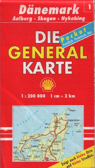
As well as Danish Shell selling maps of other countries, German Shell has sold maps of Denmark in its long-term collaboration with Mairs, publishers of the Die General Karte series. In 2000, Denmark was divided into four numbers sheets at the useful scale of 1:200,000, allowing rather more detail to be shown than on domestic Shell maps. Marketed as "Pocket", owing to their smaller format than older maps, they were printed on one side only, so were each quite fat when folded. Although printed by Mairs in Stuttgart, the actual cartography came from the Danish firm Kort & Matrikelstyrelsen. Unlike the issues for local sale, no Shell locations were marked. |
After more than a century of continuous operations, in March 2015, Alimentation Couche-Tard of Canada agreed to acquire A/S Dansk Shell. At the time Shell's Danish retail business comprises 315 sites, including 75 are unmanned automated Shell Express stations. Owing to competition concerns, as Couche-Tard had previously acquired the Statoil chain, only 131 stations were retained and switched to the Circle K or, for unmanned sites, Ingo brand. The balance were sold to DCC of Ireland which continues to use the Shell brand under licence.

Text and layout © Ian Byrne, 2000-20
All original copyrights in logos and map extracts and images are acknowledged and images are included on this site for identification purposes only.