 SHELL
SHELL
Road maps from 1915 to 1948
Shell was established in 1897 but appears to have opened its first petrol filling stations in Europe only after the First World War. Unlike the American model of a purpose built facility, most remained as streetside facilities outside motor garages or chemist's stores and in some countries, such as Britain, petrol was sold from several brands. This may have hindered the development of the oil company road map as, with the singular exception of the Mex map below, no Shell group maps are known until just before 1930.
Before Shell: Mex in England
 |
London-based Bowring Petroleum Co Ltd issued this "MEX Motor Spirit Map of the River Thames" early in the Great (1914-18) war. There are 31 small format pages of George Philip maps, following the river from Westminster Bridge to its source near Cirencester. A sticker inside the cover names Anglo-Mexican Petroleum as successors to Bowring; by 1921 Shell had taken over Anglo-Mexican to become Shellmex. There are two pages of bye-laws and two giving the story of Mex Motor Spirit. |
 |
Shell Road Maps from 1926 to 1939
 |
 |
 |
 |
The earliest known Shell map is shown above. Issued by Rhenania-Ossag Mineralölwerke AG and described as a Shell-Stellin automobile roadmap, it dates from 1926. It was prepared by Verlag Otto Schindler and the front (see panel, above left) contained a four colour map of the country at 1:1,500,000. It appears that towns with Shell-Stellin outlets were underlined in green, although the legend does not make this clear. Overleaf were 8 equal sized black & white city plans, with Shell-Stellin locations marked in red, usually by the street number. München (Munich) is shown above. The front cover (image courtesy Jon Roma) comes from a different copy of what is thought to be the same map, and the rear cover (shown above right) shows an OSSAG-Shell oil can, advertising Voltol electrically refined auto and aero-oil.

A rival claim for the first Shell maps are a pair of Paris North and South maps, dated May 1930. They appear to have been given away by Shell stations as OFFERT PAR "SHELL" is printed in bold red letters above the map. But the production appears to have been done as a commercial venture by Société EPOC using cartography by the Service Géographique de l'Armée and as well as the outstanding six panel advert for Shell (SA des Pétroles JUPITER) shown above, the maps also carried adverts for Hotchkiss, Dunlop and the Société Générale bank. The full panel is some 96cm (over 3 feet) long. They were supplied in a brown paper slip cover which bore the cartographic team on one side and a Dunlop advert on the other - no mention of Shell. EPOC did a number of other French maps in 1930, with lesser amounts of (or no) Shell advertising. A companion Shell map is known from Algeria, also dated 1930.

|

|
|
|
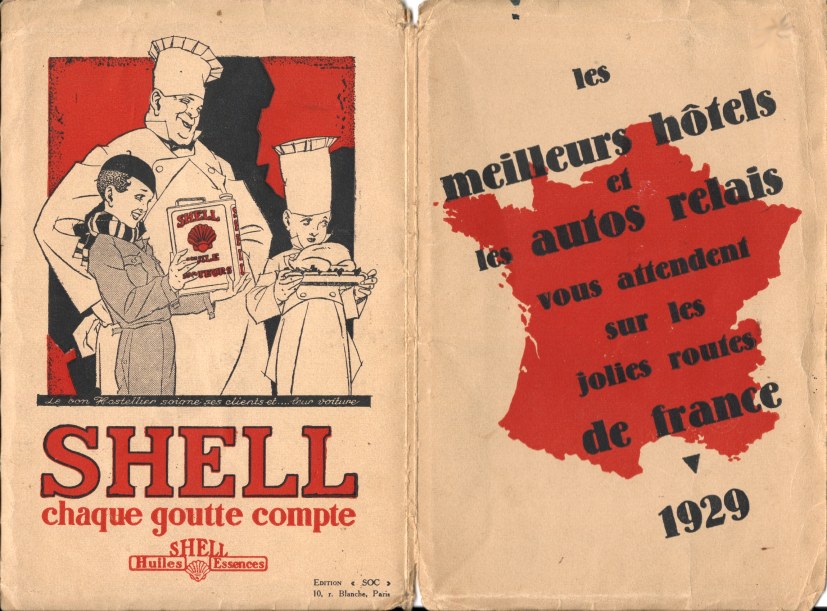
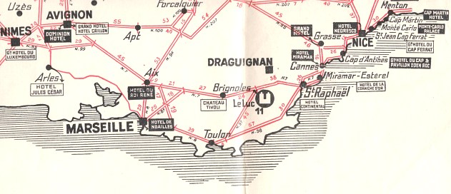
In the previous year (1929) Shell had placed an advert on the rear cover of a very basic map of France primarily sponsored by a hotel association, the Société des Autos-Relais SARL. Produced by SOC of Paris, the map reduced main roads to straight lines, but marked what it described as Palace hotels, First Class hotels and Autos-Relais, the latter being marked with a U-shaped symbol. There was no reference to Shell on the map, which was pasted into thick paper covers, but the Shell advert carried on the hospitality theme with the slogan "chaque goutte compte" - each taste counts. |
||
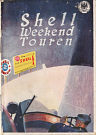
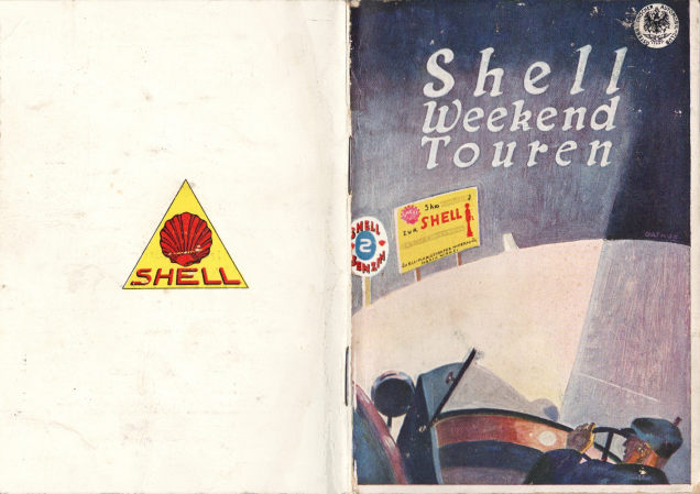
In the 1920s, Shell started producing booklets in a small number of markets designed to promote motor tourism (and so, indirectly, the sale of Shell fuels).
|
This small booklet (160x110mm in size) is called "Shell Weekend Touren" and was published around 1926 by Shell-Floridsdorfer Mineralölfabrik. With a short introduction in three languages it suggested that "there can be no greater joy for the man...than to spend the weekend in the country with his car". To facilitate this it gave very brief listings of 34 routes from Vienna, 12 from Salzburg and 8 in the Tirol. Only place names were given, except for the Tirol tours. Many more of the 80 pages were devoted to listings of all Shell stations in Austria, including 8 rudimentary b/w maps marking their location. There were a few third party adverts, including one for the 1926 model Amilcar and the Steyr Typ XII (sold from 1925-9). |
 |
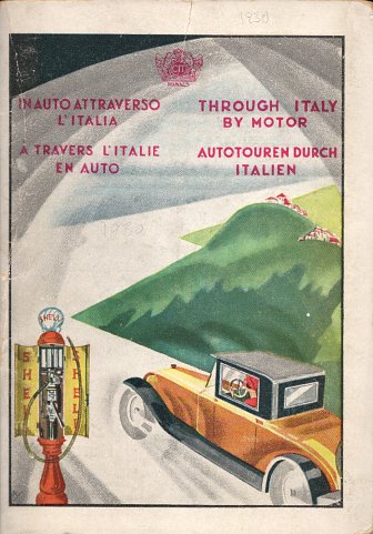
 |
This little Shell booklet of Italy dates from 1930. It consists of 20 pages of fairly low-grade paper inside a stiffer paper cover which, as well as showing a Shell pump and speedster, says "THROUGH ITALY BY MOTOR" in four languages. About half the pages are text and the other half not very detailed sectional maps of Italy in red and black. It includes pictures of road signs, and mentions the Fascist Road Militia. There are Shell logos on every page and inside the back cover is a folded map of Europe showing major roads. |
 |
As a final example of the 1930s map with Shell advertising, this excerpt is from a two-colour 1937 Magyar Touring Club map of Hungary. It locates towns with Shell petrol or motor-oil sales by a red triangle or disc, and the reverse is devoted to a large promotion for Budapest in English, French, German and Italian (but not Hungarian), with large b/w photos. The main map side carries many small adverts for banks, hotels, garages and other facilities, as well as for Shell Motor Oil. |
|
In mid-1930s, Shell's German subsidiary moved to a more American style of map without a separate cover. There were 20 sections in the main map series covering the country at 1:470,000 - the example shown is section 8 (Berlin-Brandenburg) of 1938. However there were (at least) 84 associated town plans, apparently given away freely or sold as a set. Each has a local scene drawn on the cover: a panorama of selected scenes can be found on this link. But even more Shell maps exist: there were over 100 double touring maps (SHELL=Doppeltourenkarten) numbered from 200/201 upwards. In the final year of peace, 1939, Shell extended its main maps to cover recently annexed Austria, creating 25 sections in all. With over 250 titles, this was probably the most extensive map programme ever issued by any petrol company anywhere. |
 |
 |
Before and after the War: Shell's collaboration with Foldex
 |
 |
 |
 |
In 1935, a Frenchman name Réné Costard patented a new means of folding maps that was intended to make finding places on them much easier. He named his method Foldex, and sold the idea to Shell for use across Europe. Foldex-style Shell maps are widespread (if scarce) from the 1930s: the far left is section 2 (Bretagne) from the 1936 French series at 1:400,000. Pre-war French maps have a black & white photo on the rear: the example is from a ca1938 section 1 (Nord-Belgique) that includes all of Belgium. For Belgian domestic use, a separate similar map was issued at the same scale, but adding inset city plans where Northern France should be! The final map above is a very rare example of a post-war map, dated 1946, to the same basic design. As it is of Southern Norway, Emil Moestue were responsible for the cartography. Many Foldex maps are undated, but as a general rule if main roads are grey, then it is pre-war; if they are red it is post-war. All four maps have card covers pasted to thin paper Foldex maps.
A pre-War Shell phrase book
 |
Just before the Second World War, Shell published this booklet of common phrases in 18 languages, mainly covering what to say at the service station or pump, and at the hotel. Two pages were devoted to Shell products in each country (Belgium and Switzerland were listed at the bottom of the table, owing to their multiple languages), and reveals that Shell sold fuel in Estonia, Latvia, Lithuania and Yugoslavia, but not Poland, Spain or Czechoslovakia. A gastronomic map created by Stanford in London, with no roads marked, was pasted into the rear cover with fish dishes in black, meat in blue, cheeses in green and Wines in red (although beers and spirits were included in this category too). Although undated, the fact that Austria has been incorporated into Germany suggests that it was prepared for the 1939 season. A zoomable version of the full map is shown below (although it may not work in all browsers as it requires Flash to be enabled): |
In 1948 Shell introduced a new simplified logo with the name written across a yellow pecten. Maps with this newer image are shown on the next page, covering Shell maps from 1948-62.

Text and layout © Ian Byrne, 2000-19
All original copyrights in logos and map extracts and images are acknowledged and images are included on this site for identification purposes only.