 DEA
DEA
Rheinpreussen
Brief History
|
Deutsche Tiefbohr AG was incorporated in 1899 and twelve years later became Deutsche Erdöl AG. Products were initially sold through Olex, which was acquired in stages by BP from DEA in the 1920s. After the war, DEA became an independent refiner and marketer (under the DEA brand from 1952 onwards) in West Germany. Unusually, as a late entrant to the market, it allowed a number of independent distributors (jobbers) to resell fuel under its name. Seeking growth through international expansion, in 1960 it acquired Brændsels Kompagni that supplied the ORA filling stations in Denmark. DEA also supplied a few sites under its own brand in Switzerland and Austria. In 1966 it was acquired by Deutsche Texaco AG and the DEA and ORA names were soon phased out. In June 1988 Texaco sold its German operations to RWE, a large utility company, which added them to add to its existing Union Rheinische Braunkohlen Kraftstoff business that used the UK name on around 200 filling stations. RWE decided to revive the DEA brand and over the next decade expanded operations into neighbouring countries on a small scale, opening a few sites in neighbouring countries such as Holland, Luxembourg and - through a partnership with the Swiss Migros retail co-operative - Switzerland, although the Swiss outlets were sold in 1998. |
Few sheet maps are known from the "old" DEA; this is an advert from the rear cover of a 1966 Falkplan of Düsseldorf. |

In 2001 RWE agreed to sell the DEA operations to Shell over a period of two years, catapaulting Shell to the leading market position in Germany - a position it soon lost when BP agreed to buy Aral. As a consequence of this deal, the number of DEA stations in Germany fell sharply in early 2003 as Shell-DEA divested assets to smaller companies such as Avia, Classic, Q1 and Westfalen to meet the requirements of the Cartel Office. Shell rebranded its DEA stations by late 2003, although a handful of jobber locations were still selling petrol under the DEA name as late as summer 2004.
Maps - DEA
|
|
|
|


|
In the 1950s, DEA issued relatively few sheet maps, but instead sold cloth bound "atlases", shown above at double relative size. Each had an 80 page index of cities and towns marking those with a DEA station by its logo. The maps (at 1:750,000) were by FalkPlan with a special folding system and marked DEA Stations with a green dot. In the mid-1950s nine small sheet maps by Falk were also issued covering most of West Germany, similar to the one shown below from Otto Fricke. By 1957, the series has been extended to full national coverage on 16 numbered sheets. They were augmented by occasional small format city plans on thin paper pasted in glossy covers, such as Frankfurt shown above. A red and black street map by Gutenberg-Werbung Werner & Co was overprinted with green DEA symbols. |
|

There were no DEA maps for the next 20 years, as the Texaco brand was used instead.
|
|
DEA was a regular issuer of maps from its reintroduction until 1999. As well as sectional maps of Germany, it issued a paperback road atlas and sheets covering most of the major European countries. Most maps are drawn by RV Verlag and are stock maps with attached DEA card covers and a gazetteer pasted inside the cover. The example left is a 1998 design for Switzerland, as sold in the few Swiss DEA stations; on the right is a 1999 edition described as Rheinland-Saarland (section 6 of the main German series at a scale of 1:200,000). |
|


Maps - DEA Distributors to 1968
DEA has also been distributed by independent suppliers (jobbers), probably to a greater extent than most other major brands in Germany, with some non-standard styles were used in the 1950s.


|
|
Later maps tended to use the DEA green atlas design with details of the distributor pasted into the inside front cover, as shown here by a 1959 issue from Kux & Krahn of Dortmund. Another example is shown for Casati & Lederhausen. |
 atlas of West Germany")
|
|
Otto Fricke & Co GmbH were independent DEA distributors and their details are printed on the reverse of this 1957 sectional map of West Germany, above a stamp from one of their DEA-branded service stations in Walstedde. The map is something of an enigma; the key (shown right) identifies 16 sections at 1:250,000, with relatively small overlaps, and each identifying its key city in red capitals. However this map is a 17th section, marked on the key by a dotted line, lacking a red city name, and wholly overlapped by other sheets. Given that it is centred on Gütersloh, the town where Fricke was based and that other 1957 DEA sections only show 16 sheets on the key, it seems probable that this was an extra section specially printed for use by Fricke at its service stations. |
 (at 150% relative scale) |


Fricke's history can be traced back to an import-export business established in 1858. It opened its first Fricke branded filling station in 1927 but after the war switched to the DEA brand. It supplied as many as 165 service stations in the 1960s, and carried the Texaco brand after their purchase of DEA. After Texaco's sale, it distributed fuel for the new DEA right through to November 2002 when, as a consequence of the Shell takeover, it switched its 60 remaining stations to the AVIA brand.

Although the simple DEA cover design and format of this map of Bayern-NO (Northwest Bavaria)** is identical to that of the DEA-Fricke map above, this example was prepared for Edmund Martin of Nürnberg. The panel above (which was printed by Falk onto the reverse side of the map) has four elements: one describing DEA, a key map showing only the 4 Bavarian sections available from Martin's DEA stations and not the full 16 sections, a map legend, and a panel describing Edmund Martin and its links to DEA. Martin also appears to have been established in 1911 (the same year as DEA). It is not known when it started using the DEA brand, nor whether it might have had its own independently branded maps in the 1930s. The company remained in business under the name Martin GmbH & Co as an independent jobber as late as 2002 using the Shell and DEA brands, when its 40 service stations were acquired by the Austrian company OMV.
**As further evidence that these maps were specially printed for Martin, the Martin maps carry the section names Bayern-NO, -NW, -SO, -SW. The "normal" DEA versions are respectively called after the largest city in each section:- Regensburg, Nürnberg, Augsburg and München (Ost).
A DEA atlas is also known carrying a stamp from the Optimol filling station in Würzburg. A pre-war grey-covered Uniti map is known from Anton Willer, which switched to selling DEA in 1952.
DEA Distributors - 1988-2002
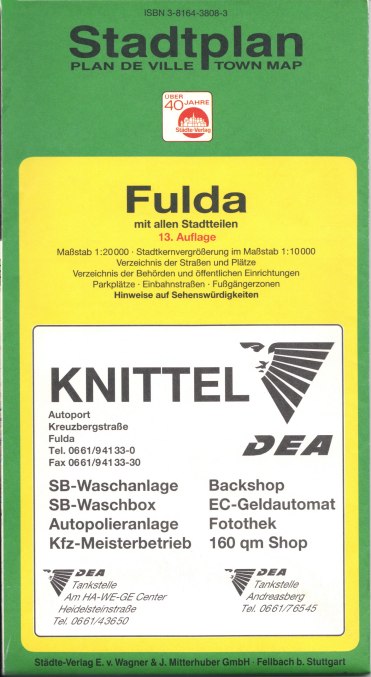
KnittelBy the time DEA was revived as a brand name by RWE, branded maps were beginning to be phased out at service stations, and although DEA inherited a number of jobbers from Texaco, only one subsequent jobber issue is known. This comes from Knittel, a long-established distributor based in Fulda that is believed at one time to have operated stations under its own Fulmin brand. It's not surprising then that Knittel chose to advertise on the cover of a Städte-Verlag street map of Fulda, listing their 3 locations. Undated, the map is thought to be from around 1993. After 2002, Knittel split its stations between Shell and Avia, and issued a customised version of the Avia map booklet in 2004. |
 map of Fulda")
|
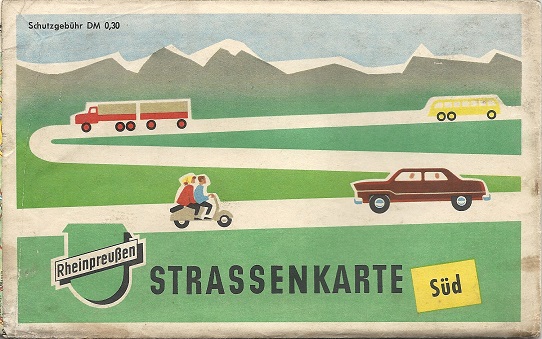
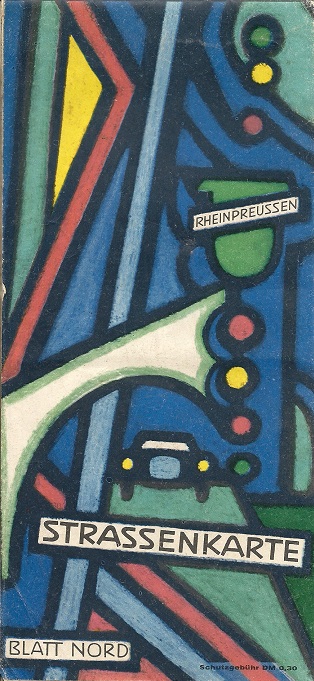
Maps - Rheinpreussen
|
Rheinpreussen was an independent German refiner that was established in 1905 and controlled by the Haniel family until acquired in two stages by DEA (1959 and 1965), when it had around 1,200 outlets. |
|


|
|
|
|
|
|


The Rheinpreussen maps of West Germany shown here are believed to date from the early 1950s through to the mid-1960s (L-R). The South and West maps above and the 1960 North (above second from right) and South (below left) were reversible covers, not separate sheets. Thyl Kohler (1910-85) was the artist credited for the 1960 map covers.
Rheinpreussen charged DM-,30 for its maps, and may have justified this through unusual cartography. Around 195 the South/West map used a patented system of "photo objective terrain" on maps by Thomas Rappel. A few years later they had moved to a wholly "flat" design by A.Holle of Offenbach, with minor roads in white on a light brown background, to make the main roads show out. |
|
|


Text and layout © Ian Byrne, 1999-2020
All original copyrights in logos and map extracts and images are acknowledged and images are included on this site for identification purposes only.