 REGENT
ZIP, Watsons
Brief History
In 1913, Trinidad Leaseholds was formed to develop oil properties on the West Indies island of Trinidad. It soon built a refinery there, but lacked dedicated sales outlets, so in 1930 it acquired a small independent distributor of petrol in Britain, Burt Boulton & Haywood, which used the Regent brand name, named after its base in East London at Regent Wharf. After the War in 1947, when pooling arrangements ceased, Trinidad Leaseholds and Texaco (which had been operating in Britain since 1916) agreed to merge their interests under the Regent brand. Within twelve months, Texaco passed its interest in Regent to Caltex - which became the brand used elsewhere in Europe. During the 1950s it became clear that a UK refinery was needed, so Texaco acquired the Trinidad Oil Company (as it was now called) to end up with a 75% stake in Regent. When Caltex was broken up in Europe in 1967, Texaco replaced Regent at 4,000 or so outlets, with just 147 switching to Chevron, its former partner. After more than 35 years of disuse in the UK, the Regent name was revived for use at stations supplied by Texaco authorised distributors from around 2004, and is currently used in preference to Team Spirit or Proteus, although the rights to the brand have been sold to GB Oils, a subsidiary of the Irish company DCC.
Maps: Regent
Regent maps are relatively uncommon, possibly reflecting low sales at its rather downmarket service stations (and the fact that its post-war maps were more expensive than its competitors').
The oldest known Regent maps are in this pre-war hardback volume, titled Regent Super Road Maps. It contains 26 pages of maps, 10 of town plans and four of third party adverts, as well as a foreword by Sir Malcolm Campbell, road signs, index marks and summaries of motor laws and foreign permits and traffic regulations. The maps, at 10 miles to the inch, were prepared by Edward Stanford, but the volume was copyright by Serials & Sport Ltd, publishers of The Field. It is undated, but the Berlin State library has a copy attributed to 1935. |
 |
 |
 |
The map left is from a rare series of six regional touring maps of England and Wales. Probably from 1953, they are noteworthy for showing many points of interest described in a full gazetteer on the reverse and having 20 small town plans in the margins. Each section's cover is a different colour, but the maps inside are a quite simple design at 6 miles to the inch. These sheet maps were not sold for long as they cost four times as much as the clearer Esso maps, so sales must have been low. From around 1953 Regent concentrated on selling a single spiral bound atlas of Great Britain at 10 miles to the inch. |
 |
 |
 |
 |
 |
 |
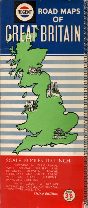
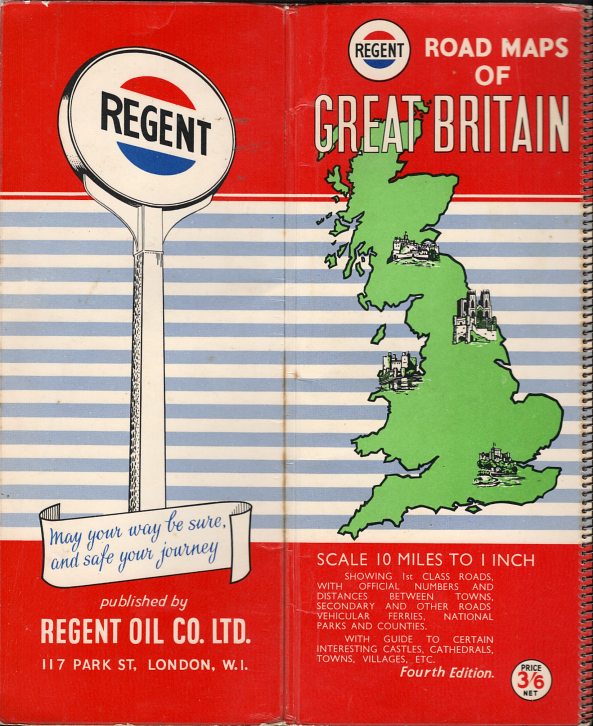
The country was covered in 30 small sections (including two for London) arranged so that each sheet was about 0.2 inches wider than the one before, for easy access to the required page. All maps were drawn by Geographia and only the 1960 edition (far right) was dated. The first edition cost 2/6d; later ones a shilling more. It is possible that the very first edition was a special version to mark the coronation of HM Queen Elizabeth II in 1953 (top right). There are actually significant variances within each edition; later first editions cost 3/6d, were laminated in cellophane and had a different rear cover. The second edition comes with two different maps of London - a simple planning map and a more detailed street map of central London. The third edition is superficially similar to later second editions, although the Regent logo is shown on a black square background. The fourth edition is similar to the third, except that the background in now predominantly red; it has the same banjo sign rear cover as the second and third ones. The final edition (above right, coded 1960) includes examples of (short-lived) motorway signs. The middle three editions are described as "road maps" and the first and final as being a "road atlas". All the Regent sheet maps and atlases on this page were specially prepared for the company by Geographia Ltd.
and atlases.
Coronation atlas image courtesy Richard Horwitz
 |
The final spiral atlas and the first sheet map (left, estimated at 1961) used a design almost identical to that of Caltex maps from Europe in the same period. Britain was divided into two sheets, each at 9 miles to the inch, and sold for a shilling. The later example (right) comes from approximately 1964 and uses a design unique to Regent. However around this time they introduced a Greater London route map (far right), which was backed by a large scale map of central London. |
 |
 |
 |
From around 1965, Regent also sold to a series of five sectional maps at 5 miles to the inch (except Ireland). The Greater London map refers to this series being sold alongside the two smaller scale maps, as well as a "pictorial map of London". Most commonly found in the dull, bluey-green covers, their final version showed both the Regent and Texaco logos on the cover and referred to "Regent Oil Company, a Division of Texaco Ltd". However the Texaco logo was only used in this format in Northern Ireland; the version used in mainland Britain lacked the star. |
 |
 |
Although Regent maps of Ireland are missing from the early British series, this 1958 map (with cartography by Orell Füssli) carries both Regent and Caltex logos. It may have been produced for distribution in Northern Ireland (where it is thought that the Regent name was used), or it may have been for mainland British distribution. A Caltex version of the same map can more commonly be found. |
|
Maps: ZIP
Russian Oil Products (R.O.P.) distributed petrol within the UK during the 1920s and 30s at a slight discount. However after the War, the Soviet Union was in no shape to provide secure supplies, and R.O.P. was sold
to Regent in 1948.
 |
R.O.P.'s petrol used the ZIP name in the 1930s and for three years from 1936 free maps were produced by the company. The 1936 version (left) had the rather plain cover shown and was supplied in an envelope of the same design. A specially printed map from John Bartholomew and Son at the (metric) scale of 1:1 million was pasted inside the covers. In 1937 (right, front & rear) a smaller format was used encompassing a Geographia map at a similar scale. The front cover showed the oil producing areas of Russia between the Caspian and Black Seas where R.O.P.'s crude oil came from. |
 |
A 1937 map of just Scotland can also be found with the cover design showing the Caspian oil region. This has inset maps of Glasgow and Edinburgh which, uniquely, indicate the location of ZIP filling stations. It is possible that this was a special version, printed in small numbers, for the 1938 Empire Exhibition.
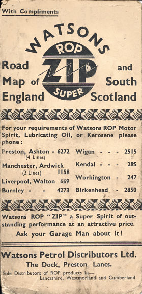
Maps: Watsons
Watsons Petrol Distributors Ltd was a franchised "jobber" for R.O.P./ZIP, based at Preston in Northwest England.
 |
Watsons gave away customised versions of both the maps above. The 1936 version only differed by its front cover (left), but the 1937 map (right) had a different front cover, and all references on the covers (including inside) were changed from "R.O.P. ZIP" to "Watsons R.O.P. ZIP". The actual maps by Bartholomew and Geographia were identical to the more common version. After the war, Watsons became the sole distributors of Fina products in Wales and the West of England. |
 |

Text and layout © Ian Byrne, 2000-14
All original copyrights in logos and map extracts and images are acknowledged and images are included on this site for identification purposes only.