 CHEVRON
Brief History
In 1967, Standard Oil Company of California (Chevron) and Texaco agreed to end the Caltex joint venture in Europe. Chevron took the largest share of downstream activities in West Germany, Switzerland, Italy, Benelux and Denmark, although Texaco gained some outlets in each country. Texaco obtained the larger chain in Britain (Regent), with a few service stations passing to Chevron. Chevron kept no interests in other countries, including the rest of Scandinavia and Ireland. Chevron added to its activities in Holland and Denmark by merging with those of SHV, which had used the PAM trademark. Fuel oils and marine operations used the Calpam name for the next twenty years in these two countries.
By the early 1980s, Chevron decided to concentrate its marketing efforts in the USA. Switzerland had gone first, to Gulf in the late 70s, and then the rest of Europe except Italy was sold to Texaco in 1984. Finally, the Italian operations were sold to the independent refiner ERG in 1986. However this was not the end of Chevron's European retail interests; the purchase of Gulf brought it a small British chain (which was retained under the Gulf brand until sold to Shell in 1997). And in 1996, Chevron opened what was claimed to be the first Western branded station in Almaty, Kazakhstan, a country in which it has major exploration interests. In a final twist, Chevron acquired the whole of Texaco in 2001 to form the inelegantly named ChevronTexaco. However it again decided withdraw from Europe, selling off the Texaco assets over the following decade to buyers such as Israel's Delek (in Benelux) or Valero (in the UK and Ireland).
Maps
More than most companies, Chevron imposed a uniform style on its operating subsidiaries and virtually no non-standard map designs are known.
|
|
|
|
|
This 1971 Chevron map of Switzerland by Kümmerley & Frey had reversible covers. One side was of a family car (loosely modelled on a Peugeot), which appeared in a mirror image on the English map, presumably to ensure that the driver of the car was on the right side. |
The 1971 map of England and Wales by Geographia was similar but had card covers and not totally reversible. Chevron had no service stations in Scotland or Ireland, so did not need a map of all the UK. |
By 1976, the country was no longer highlighted on the map of Europe as can be seen on this Netherlands example; inside was a standard Falkplan map. |

")
")

|
|
|
This map of South East Germany (left) is possibly the oldest European Chevron map in existence. Although it is in Chevron's standard blue and white colours, the Chevron logo is actually a sticker applied on top of a Caltex logo, so it was presumably issued around 1968, when it was sold for 75 pfennig. Inside the map is drawn to 1:500,000 by Hans König, and the rear cover promotes Chevron's Boron grade, showing a Ford Taunus parked beside an autobahn. Chevron may have recycled old Caltex maps in this way as they had a relatively small chain of 750 service stations in Germany. |
|
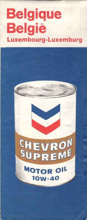
The Chevron map of Belgium and Luxembourg is another early issue, with reversible covers. One side shows a typical outline map of Europe in a rather darker blue than on later maps, with the post-1968 logo. The other side (above right) features an oil can, still carrying the older Chevron insignia (which was only used in Europe at British service stations). Internally the map was produced by the leading Belgian cartographer De Rouck, although it was printed in Germany. Only 20,000 copies were printed. There is also a Kümmerley & Frey map of Benelux pasted into Chevron card covers with a similar rear cover design. | |||

")

|
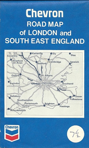
Dating from 1969, this Chevron map of London and South East England uses cartography by George Philip & Son, similar to that on Shell maps, except that areas of woodland are shaded in a very light green and the scale was 5 miles to the inch. It is possibly a unique map covering the part of the country with most (but not all) of Chevron's initial chain, as it lacks a section number or any indication of other maps. |
|
|
|


Early maps were often simple paperback productions, but by the mid-1970s most were in card covers, often using cartography by Kümmerley & Frey – including a 1974 map of England Wales and Scotland which is the only known example of a domestic sold map of Britain using them. Rear covers were also usually common between countries, and can be helpful in dating some of the maps. The earliest ones showed a Chevron Supreme oil can; then came a car with upturned boat on its roof; this was followed by the blue "Peugeot" cover shown above and a similar design featuring a red car not unlike an Opel Manta; next was a humorous scene featuring a car towing caravan – all at a Chevron service station, and finally two montages featuring an attendant, pump, station, cloverleaf junction and Chevron Super Golden oil can.
A slightly different Chevron cover, without the outline map of Europe, is shown on the Luxembourg page.

Text and layout © Ian Byrne, 1999-2016
All original copyrights in logos and map extracts and images are acknowledged and images are included on this site for identification purposes only.