 CLEVELAND
Brief History
Initially established in Manchester & Preston in 1920, the Cleveland Petroleum Products Company was acquired by the Petroleum Storage and Finance Corporation in 1928. (The name is thought to come from the Cleveland Hills, not from Cleveland, Ohio.) In 1934 it started marketing an alcohol mixture called Discol, produced as a byproduct of whisky distillation by the Distillers company. In 1938 the Anglo-American Oil Co (Esso) acquired a majority interest, but the Cleveland name was retained, largely so the subsidiary could continue to market the alcohol and benzole blends. This gave Cleveland five different petrols at a time when many firms had only two or three.
Although it was wholly owned by Esso from 1958, the Cleveland brand was retained until 1973 when the group gave up selling benzole or alcohol blends. Cleveland's 2,000 filling stations were soon switched to the Esso brand.
Maps
|
No Cleveland maps are known before this 1963 example which is in often found in poor condition. The map was printed abroad, probably in France, by Foldex on rather poor quality paper. As with all Foldex maps, there is a fair amount of detail considering the small scale (10 miles to the inch). Britain was covered in two sections (North, with a red cover & South with the light blue cover shown); Ireland was missing from all Cleveland series as it only opened its first station in Northern Ireland in 1972. |
|
||

|
|
|
|
|
|
|
The first George Philip series from 1967 had relatively dull covers. There are two rear covers; the first lacks a red top band and has an error "Drive with Driscol" (not Discol) overprinted. |
The next series dates from 1969-70 and had seven line drawings of minor landmarks. Section 7 - Northern Scotland - showed Dounreay nuclear power station and Section 4 - South East England - shows the Civic Centre in Southampton. The 1970 maps showed both old and decimal prices. |
The final series from 1972 used less fluid ink wash drawings of castles. The Midlands & East Anglia (Section 4) is represented by Tattershall Castle in Lincolnshire and Northern Scotland (Section 7) by Crathes Castle, West of Aberdeen. |
||


 |
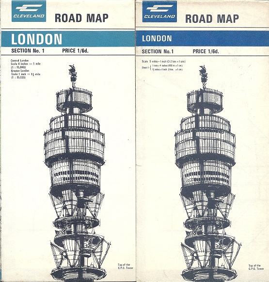
The 1967 maps use a lighter shade of blue, with a slight greenish tint, which more accurately reflected the plastic signage used at Cleveland petrol stations. There are two versions known of the 1967 London maps: one with the outline GB cover, and a second following the general style of the 1969 series, but still using the lighter blue. This map also had the updated content, with the whole of Greater London shown at 1:95,000 rather than just inner London at 1 inch to the mile. The blue plate was also revised before being reprinted in the darker blue in 1969, as the font size on the cover changed. |

Text and layout © Ian Byrne, 1999-2019
All original copyrights in logos and map extracts and images are acknowledged and images are included on this site for identification purposes only.