 GULF
GULF
Brief History
Unconstrained by agreements between Standard Oil companies, Gulf Oil Corp. of Pittsburgh became a major force in many European gasoline (petrol) markets in the 1920s and 30s. Forced, on financial grounds, to sell its French operations, it continued to operate in Scandinavia, Benelux, Italy and Switzerland in the 1950s. In the early 1960s it started building a new chain in Britain and acquired 750 Frisia outlets in Germany and Luxembourg in 1969. However Gulf nowhere ranked higher than fifth position except in the tiny Luxembourg market.Dependent on Kuwaiti oil, within 5 years it resold its German chain to Stinnes Fanal and in June 1983 sold its Swiss operation to Shell, despite having not long bought out Chevron there. In the next few years Benelux, Sweden/Denmark and Italy were all sold to Kuwait Petroleum (Q8) - who produced a transitional map of Belgium with the Gulf logo and Kuwait Petroleum name around 1984 - leaving only the small British chain.
Chevron's purchase of Gulf ended the sales policy, and Gulf petrols remained on sale at British filling stations for another decade, until Shell bought the chain in 1997.
The Gulf name was bought by the Hinduja family, and since 1999 has been licensed to a small number of companies in Belgium, Germany, Ireland (which had never had Gulf stations before), the Netherlands and the UK, as well as some in non-European countries including Madagascar. In 2007 the Gulf name was reintroduced to Sweden, replacing the small brands QStar and Pump.
Maps:
|
|
|
|
|
|
|


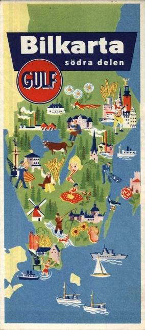
Gulf issued maps in the 1950s in all its main markets, bearing the old orange disk logo. The first two examples are from 1958. Switzerland (left) was covered in a single sheet drawn by Kümmerley & Frey at 1:600,000 with a slightly over-sweet cover photograph. Sweden was divided into North and South sheets by Kartlitografen to the same scale; neither map located Gulf service stations. The next Southern Sweden map shown dates from 1959. The remaining three maps are from 1957, 1959 and 1965 (with the later logo) respectively and are all from Finland, where Gulf was an important player until it sold its chain to Finnoil in the 1970s.
Finland images courtesy of Juha Tuulaniemi; 1959 Sweden from Wilhelm Feuer
|
In 1953 Gulf's Dutch subsidiary published this map showing access routes to the first post-war Flora exhibition. This event was held in Heemstede, just South of Haarlem, and the map showed access routes to the main entrance and car parks from Amsterdam, Den Haag and Utrecht. |
|
|
")
")
|
|
Gulf's Belgian chain used map cover designs similar to those on American road maps. The map of Western Europe (left) from around 1960 looks like a US one of 1960-3 vintage and a Belgian map of the same design can also be found. The map of Belgium (right) uses the 1964-8 style of cover (although it was used on some US city plans as late as 1970). These maps have cartography by Dossray of Brussels at scales of 1:4mn (Europe) and 1:300,000 (Belgium). Images courtesy of Michel Breugelmans |
|


|
|
In the late 1950s, Gulf experimented with a transitional sign, shown on this Falkplan of Benelux, which used a patent dissected strip folding. It then moved to a short-lived updating of the disk, shown on the 1964 Southern Sweden map, before the more familiar modern image, shown on a map from the following year. Both Swedish maps sold for 1 krone and located Gulf service stations. |
|
|


|
|
|
These images show the alternative covers for a 1963 Gulf map of Europe - neither side is obviously meant to be the front or rear. This edition, which again carries the transitional sign, was prepared in the USA for Gulf by Rand McNally, Gulf's US cartographer. Europe was spread across the two sides at 1:4,000,000, and the legend was in 11 languages, unusually treating Flemish as distinct from Dutch. By 1965 (right) the new logo was used on both covers. |
|


|
|
|
Later Gulf maps of Belgium and Luxembourg no longer followed US designs. The two maps shown here probably date from around 1969-70, and it is thought that the left one is earlier. Both were produced by and mark towns with Gulf outlets but at the scale of 1:320,000. Inside they promotes "FORT" trading stamps, given away under the sign of a red rose. Belgium was one of the few countries in Europe to use trading stamps widely. |


 |
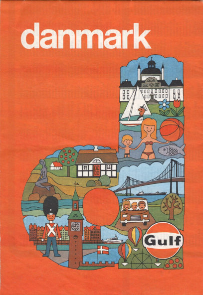
Gulf's 1969 map of Denmark (left) was prepared by I.S. Jensens at the typical Danish scale of 1:510,000 and included city maps of Copenhagen, Aalborg, Odense and Århus on the reverse. 1970s Gulf maps often have a family resemblance across Europe, as in the very late example from Denmark, shown right. Produced in 1984, it looks much like the 1971 British map below or the centrally produced atlas shown on the brands listing page. Only Gulf locations in the four cities on the reverse are indicated of this Folia/Legindkort map. |
 |
 |
For its 1972 map of Switzerland, Gulf took a stock Hallwag issue and pasted it into custom card covers: the reverse side was in German. Some city maps were shown on the inside of the covers. |
|
|
In 1976, after the oil crisis had eased, Gulf and Avis rentacar collaborated on a map of Italy (above right), prepared by Vallardi in Milan. All the advertising on the map is for Gulf, not Avis - the oil cans are framed in the words PER VIAGGIARE MEGLIO (for better journeys). |
||

|
|
|
|
|


The final example is unusual for it is basically a nature trail written by the comedian turned birding expert, Bill Oddie. Produced in association with the Nature Conservancy Council it describes wildlife and nature sites along the M4 motorway. Similar nature trails were produced for at least four motorways: the M6, written by Richard Mabey in 1982; the M4 in 1983, the M5 (David Bellamy) in 1984 and - probably finally - the M25 (Spike Milligan, with some poems) in 1987, by which time Gulf was owned by Chevron. There were no issues in 1985 or 6.
|
|
The final Gulf map from Europe was this small format 1996 road atlas of Britain produced jointly with Fina to promote their credit card exchange programme, but sold for £3.99. Although produced by the AA, two pages had to have corrections pasted over them. |
Detail showing the Gulf network account card and the FINACard Business Account from the cover of the 1996 atlas. |


Although not of European maps, this site has a page showing how to date early Gulf maps from the 1910s and 20s.
Gulf (since 1999)
|
|
The 'ronde van Vlaanderen' or tour of Flanders is the biggest one day cycling event in Belgium. A special map was produced by 'Tourism East Flanders' in cooperation with Gulf (or more likely its Mazout Express franchisee) in 2002, and was given away at Gulf stations. The image shows only half of the map; when fully opened out it reveals a larger map (at 1:72,055) with a detailed route of the cycling event. |


Text and layout © Ian Byrne, 1999-2015
All original copyrights in logos and map extracts and images are acknowledged and images are included on this site for identification purposes only.