 German independents since the 1970s
Relatively few German independent petrol suppliers have sold own-branded road maps since 1970.
Divinol
Brief History
Zeller + Gmelin was established in 1866 and has operated for at least a century in Eislingen. At some stage it either acquired or introduced the Divinol brand, and certainly supplied some filling stations under that name by 1971. However the 1972 map shown below suggests that the Divinol name was only used on automotive and industrial lubricants and that fuels were sold under Chevron colours. ErdölInformationDienst relisted ORAG/Divinol as a supplier to the German market in 1986, a couple of years after Chevron sold out to Texaco; it's not know if Divinol was used at petrol stations between 1971 and 1986. After 1986 ORAG and Divinol numbers drifted down from 81 to 58 at the start of 1992, after which EID no longer listed the brands. However a handful of stations remained in ORAG colours until at least 2002, and a couple may still survive. Zeller + Gmelin retained the Divinol name for use on lubricants, sponsoring the Divinol Cup motor race in the mid-2000s. The parent company also sells specialty chemicals, printing inks and varnishes.
Maps
 |
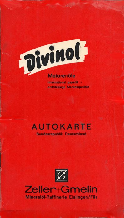
Like the Turbotank map below, this is a generic card cover attached to a Falkplan patent folded map. The cover only promotes Divinol motor oils although the full range of Zeller + Gmelin's product is listed inside the cover, including Chevron fuels and Thermol heating oils. The map itself is at the scale of 1:650,000, pasted onto the inside rear cover and it has a 72 page index stapled into the spine. |
 |
 |
This map is probably a year later than the Falkplan one above, being dated 1972-3 and prepared for them by JRO. It is their standard map of South Germany at the scale of 1:300,000 with the head office location at Eislingen marked on the map. Unlike the other map, it makes no reference to selling Chevron fuels. |
|
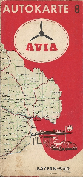
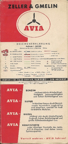
Considerably older than the Divinol maps shown above, this 1956 Avia map of Southern Bavaria was specially printed for Zeller & Gmelin by Falk-Verlag of Hamburg at 1:500,000. Although numbered 8, it's quite possible that only the South German sections were customised in the this way. The bleed onto the cover includes the Western extension of the map to Passau at a slightly smaller scale than the main map. |
") |
 |
Raiffeisen
Brief History
Raiffeisen takes its name from Friedrich Wilhelm Raiffeisen (1818-1888), the founder of the German co-operative movement. It's not known when the various agricultural co-ops using the Raiffeisen name first started to sell fuels, nor when they expanded to include motor spirit, but numbers have increased steadily over the past 30 years, and Raiffeisen now supplies modern self-service filling stations as well as small unmanned sites attached to agricultural merchants. The Raiffeisen website (2014) claims that they have 631 filling stations, but this includes 95 branded Baywa (principally in Bavaria) and 148 owned by Baywa's subsidiary Tessol but using the Avia brand, as well as others that may not be directly accessible from the public highway or be only weakly branded Raiffeisen. However, there has been an apparent moved to bring in some of the branches using non-standard names, such as ZG Raiffeisen to the main identity. Although there are Raiffeisen co-operatives in other countries, if they sell petrol it is under other names, such as Genol in Austria.
Maps
 |
With a decentralised structure, it is not unsurprising that no formal Raiffeisen maps are known. The map illustrated here is taken from an undated leaflet promoting Raiffeisen Westeifel, one of the smaller co-ops within the movement, with just four depots, centred on Weinsheim in the Rheinland-Pfalz. It is not known if all these locations also sell petrol, but probably only two of the four marked on the map do so, including a large modern filling station in Prüm, from where the leaflet was obtained in summer 2010. The map was created by Naviteq and is sufficient to find the Raiffeisen locations, but of limited use as a map of the region. |
Turbotank
Brief History
Bösche und Bödeker GmbH was established as far back as 1919 in the German port city of Bremen. A small chain of filling stations was established before the Second World War, but hostilities caused the company to retrench to a single service station in Bremen's Neustadt district. After the war it expanded rapidly reaching 20 filling stations by 1958, and having only five fewer outlets twenty years later. Since the early 1990s the company has focused more on the wholesale trading of fuels, lubricants, heating oil and other products such as propane, although a the turn of the century it still operated 4 service stations in the Bremen area. In recent years it developed a web presence in online lubricant distribution and heating oil trading, but in the past few years may have gone out of business, with its remaining stations possibly passing into the Hoyer network.
MapsTurbotank has occasionally sold maps and the cover design shown here was used from 1989 until the early 2000s. Stocks were held of a standard A5 format card cover which can then be fixed to any competitive road atlas; ones produced by Falk-plan with their patent folding system have been used most often. The atlas normally includes a map of Germany and insets for the largest cities, but the cover carefully does not commit the company to a fixed content. Indeed, this design was first used before unification, but was sufficiently non-specific to survive! |  |
There have probably been other German independent brands that have issued maps over the past 40 or so years that I am not aware of. If you have any examples, please send me an e-mail.

Text and layout © Ian Byrne, 2000-15
All original copyrights in logos and map extracts and images are acknowledged and images are included on this site for identification purposes only.