 How often were maps reprinted?
Introduction
When I first started collecting road maps, I thought it was likely that the more common maps were updated and reprinted annually. In effect, there would be a simple pattern of one map per year for each section and brand. However it became clear that this is not always the case, as will be shown by some examples on this page. In truth, few brand development or marketing managers would have marked their calendar for an annual update; most would wait until service stations were asking for more supplies to avoid the risk of having to pulp or sell old editions off cheaply.
This page looks at a few examples where there appear to be more frequently issued maps.
A clear example from the USA, dating from 1973-4
In the USA, where map programs appear to have been strongly influenced by the big three publishers of Rand McNally, HM Gousha and the General Drafting Co, most major brands did appear to be on an annual update cycle. Esso group maps changed their cover design annually in the 1950s and 1960s, but there is often more than one edition for each design indicated by a small MMYY (month-year) code printed on the rear cover. Although not common, multiple issues for a single year are also known from a number of other major companies including Mobil, Sohio and Standard/Amoco (see below). Smaller firms seem to have had maps prepared less frequently, perhaps because many were price led and the overhead cost of free road maps was seen as unjustified.
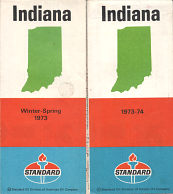 |
There are some clear examples of maps being issued more often than once a year. Even though free maps were beginning to disappear around 1970, Standard Oil Co of Indiana (Amoco) moved onto a more regular cycle for its new maps funded partly by third party advertising (and created by its Tempo Designs subsidiary). The two Indiana maps shown here are clearly dated on the cover "Winter-Spring 1973" and "1973-4"; although they were actually copyrighted 1972 and 1973 respectively. Maps can also be found for "Summer-Fall 1972" and "1974", suggesting that the gap was nearer eight months. |
 A 1973-4 example from the UK
In Europe, where maps were more often sold rather than issued freely, fewer copies were distributed so despite smaller print runs, there was perhaps less chance of needing a mid year reprint.
 |
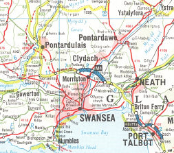
However it is not unheard of; this Texaco map of Wales and Central England has a cover design that was used for a number of years in the early to mid-1970s. Texaco had its maps prepared for it by Geographia Ltd and, unlike most other UK cartographers, Geographia also indicated the month and year of issue, using the CUMBERLAND date code. I have examples carrying codes U.LM (February 1973), N.LM (September 1973), L.LB (July 1974), as well as later ones such as A.LR (August 1976). It's interesting to speculate on why Texaco went through three editions in 18 months, just at the time of the "oil crisis": maybe it had underestimated demand for maps and slashed print runs, or maybe motorists suddenly wanted to be certain that they were not wasting valuable fuel on badly planned journeys. These were not simply reprints; maps were updated each time as can be seen from the two paired extracts shown here - the first two are of the Swansea area. |
 |
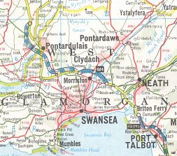 |
The first image is used on the two 1973 maps, and the second one on the 1974 edition. Note how the Pontardulais bypass has changed from a projected route to the M4 under construction, and the A48(M) is also being built South of Port Talbot on the later map. |
 |
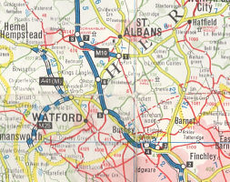 |
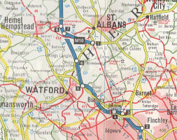
The lower two extracts are of the area around Watford to the NW of London. The first map comes from the February 1973 edition; the second is as shown on the later 1973 and 1974 maps. |
Here the construction work on the A41(M) appears from nowhere; when opened of course it was simply the A41 and never assigned motorway status. And the Watford Northern bypass moves from a projected route to the M25 under construction; the road carries that number today but when first opened was the A405. Both these roads should have still been shown used a red dashed line under Geographia's convention.
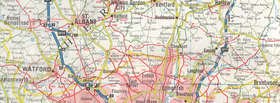 |
The problems in setting the route of the M25 North of London can be seen from the larger extract, taken from the first of these maps (although still shown on the same routeing as late as the August 1976 map). |
The M25 splits NW of Brentwood with a Northern spur passing to the North of Epping, through Hoddesdon (where tiny bit exists as a spur of A10) to join up with the A414 SW of Welwyn (at Letty Green). The Southern branch follows the eventual route of the M25 as far as South Mimms, but then take a more Southerly course passing close to Radlett before reaching the M1 near Bushey. Texaco/Geographia were very slow to update this compared to George Philip on its maps for Shell and Esso; indeed the first bit of the M25 to be built running East from South Mimms is labelled as M16 on the 1976 Texaco map - when opened it was actually A1178 for a number of years before becoming the M25.
 A counter-example: Shell-BP from the 1950s
The day books of George Philip & Son show order dates, invoice dates and quantities of maps printed for their main commercial customers, but can be frustratingly vague about detail (including, crucially whether maps were in Shell, BP or National Benzole colours, when the order was simply placed by Shellmex and BP Ltd).
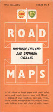
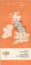
However we can tell that maps were occasionally reprinted without corrections, and some sections had extra reprints - presumably because they had sold out, but potentially to reflect a major motorway opening. These day books also reveal that in the 1950s, Shell and BP maps were printed in sufficiently large quantities that they did not need to be reprinted for several years (possibly because sales were disappointing compared to the much cheaper Esso maps). Indeed the series with both Shell and BP logos on the cover appears to have been commissioned in 1951, printed in 1954 and never reprinted. Some 292,000 copies of section No. 4 alone were initially printed, but as late as September 1959 Philip's specially overprinted the rear cover for attendees at the annual meeting in York of the British Association for the Advancement of Science (far right). |
 |
 |
In contrast, Esso's British maps appear to fall almost neatly into a one edition per year from around 1950 until 1979, based on the tentative Esso map dating system I developed a few years ago with the help of US collector Stan DeOrsey. Of course from 1958 onwards maps were dated which makes it a whole lot easier, and there are very few examples of different Esso designs carrying the same date. But the first maps from Esso's predecessor are a lot more confusing...
 Four Pratt's atlases with the same copyright date
Going further back, to the very start of the last century, Esso's predecessor Pratt's offers a real conundrum. They issued a Road Atlas of England and Wales - but there are no fewer than four slight variants carrying the date 1905, with the next edition carrying the date 1914. It is highly unlikely that all four variants were actually published in 1905, but more probable that they appeared over the next 8 or so years.
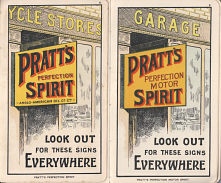
The four 1905 variants are most easily distinguished by their cover and the frontispiece advertisement for Pratt's motor spirit:
 (a) |
 (b) (c) & (d) |
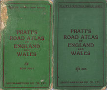 |
(a) Measures approx. 6in by 3 3/8in (152 x 87mm). Light Green covers, printed in red. No reference to Spirit on cover. |
 (a) |
 (b) (c) & (d) |
 |
|
|
|||
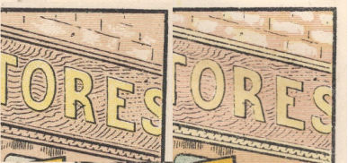
A possible indicator as to the sequence may come from the way that the plate used in (b) appears a lot less sharp than that for (a) suggesting that it may have become worn (and thus that (a) was the first design, with (b) coming next. There is little doubt that the next two in the sequence will be (c) then (d), as all subsequent atlases are the same size and refer to Pratt's Perfection Motor Spirit.
![]()
All original copyrights in logos and map extracts and images are acknowledged and images are included on this site for identification purposes only.
