Dating British Esso Road Maps from the 1950s
Warning! This page is quite academic in nature, but I hope it may be of some interest to map collectors and the curious. There is a summary table at the end which should help date any map that you might find.
|
|
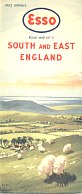
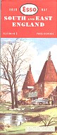
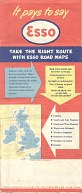
At first sight, there are just two Esso map styles that were used in Britain and Ireland in the 1950s. Each style of cover was issued in a series of nine maps carrying a watercolour image of a local scene. Those in the first series were generic scenes rather than specific places; the second series named the view depicted (so section 2, shown here, is noted as being oast houses in Kent). The design of the first series matches that of 1949 USA Esso maps. |
|
|
|
|
|
|
|
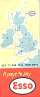
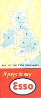

There are actually seven known rear cover variants, of which six are shown above in age order. All the rear covers show the available sheets on a blue outline map of the British Isles, with a yellow and white wavy background (which does not reproduce too well on a reduced size JPEG file).
The oldest (I believe) is a vary rare variant Aa with an Esso logo in a compass rose floating in the North Sea. So far this is only known on two map sections (South and East & South and West England, nos. 2 & 3). It may even be a later, short-lived variant of rear cover Ab which is much more common. Both Aa & Ab are used with the oldest cover design. The Aa example is copyrighted "Anglo-American Oil Co. Ltd"; Ab can carry the same copyright or that of "Esso Petroleum Company Ltd", which succeeded Anglo-American as the legal entity selling Esso petrol in 1952.
The "Esso Petroleum Company Ltd" maps with rear cover Ab are the most common of the A rear cover designs. There are in fact two versions of these maps - the earlier with "PRICE SIXPENCE" over-printed on the front cover, usually in black, and sometimes with a heavy die scoring the paper, and occasionally not well aligned. Later versions had "PRICE SIXPENCE" incorporated into the blue printing plate.
The next group of variants use the first cover design but have rear cover Ba and are also relatively common. Although the outside covers do not change, there are actually two versions with significant changes inside.
 
|
The style of the map border was changed, the sea was switched from a solid turquoise to a lighter blue, and there were changes to the colouring of some "A" roads. |
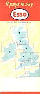
The very last Esso maps with the older front cover had a transitional rear cover Bb - not illustrated - which is the same as Ba above except that it highlights the section of the map in pink. Bc also does this, but adds the Shetland Isles to the outline map and uses stronger colours on the rear cover. Another minor difference is that on Ba & Bb, the border of each section as marked on the rear cover outline map is red, whereas on Bc it alternates between red and black.
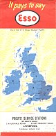
Around 1956 a completely new front cover design was used, with the then standard red top bearing the location and Esso roundel. At this stage the picture was removed from the index of places. The first versions of these had rear cover Bc; the example above shows how it could accommodate a dealer stamp from the service station; (in contrast Esso maps with A rear covers often have the dealer stamp on the pastel front cover). This new style appears to have been used for two years (1956-7?) as for some sections there are known variations to the map inside (eg. the removal of the Race Course by Gatwick Airport). On section 1, the background to the London Underground and Theatre district maps changes from white to yellow; main roads on the latter change from black to red and the Thames becomes filled in with blue on the Underground map.
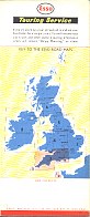
In 1958, Esso started adding a copyright date to the maps. It always said "(revised)" after the date, as the initial version was not itself dated! The rear cover changed to C, giving prominence to the Esso Touring Service. Maps with this design of front and rear covers can also be found dated 1959 & 1960. Finally, the rear cover design was changed again to one where the wording at the top stated "ESSO TRAVEL AIDS ARE AVAILABLE FROM YOUR ESSO DEALER". This rear cover design is found on maps dated 1960 and 1961. However for some sections (including London, Wales and Midlands and Southern Scotland), the 1961 front covers no longer used the watercolour but instead a photograph. By 1962, all sections used photographic covers on a smaller format map which was folded at the top not the side.
Two further styles of rear cover were used on the Norfolk Broads and Rivers maps. The earlier one (near right) promoted just the domestic Esso map series and highlighted, as one of the features of these maps, Spot-heights and county boundaries. The later design (far right) also mentioned the four continental phrase books and the Free Esso Touring Service available by sending an enquiry card, available from your Esso dealer, by post to Paris. The key to the UK sectional maps are essentially Ab and Bb, but reduced in size. Although the Esso Travel Aids strip (as used on design D) is used on the later cover, the map is definitely earlier than 1960-1. |
|

|
| 1949 | Old front cover, price not pre-printed; rear cover Aa (compass rose); © Anglo-American; car in index |
| 1950 | Old front cover, price not pre-printed; rear cover Ab; © Anglo-American; car in index |
| 1951 | Old front cover, price not pre-printed; rear cover Ab; © Anglo-American; car in index |
| 1952 | Old front cover, price not pre-printed; rear cover Ab; © Esso Petroleum Co; car in index |
| 1953 | Old front cover, price pre-printed; rear cover Ab; © Esso Petroleum Co; car in index |
| 1954 | Old front cover, price pre-printed; rear cover Ba; © Esso Petroleum Co; car in index |
| 1955 | Old front cover, price pre-printed; rear cover Ba; © Esso Petroleum Co; bike/caravan in index Old front cover, price pre-printed; rear cover Bb; © Esso Petroleum Co; bike/caravan in index |
| 1956 | New front cover; rear cover Bc; © Esso Petroleum Co; no picture in index |
| 1957 | New front cover; rear cover C; © Esso Petroleum Co; (last year with no copyright date) |
| 1958 | New front cover; rear cover C; © Esso Petroleum Co, 1958 |
| 1959 | New front cover; rear cover C; © Esso Petroleum Co, 1959 |
| 1960 | New front cover; rear cover C; © Esso Petroleum Co, 1960 New front cover; rear cover D; © Esso Petroleum Co, 1960 |
| 1961 | New front cover; rear cover D; © Esso Petroleum Co, 1961 |
