 PRATT'S
Road Atlases of England & Wales and Scotland & Ireland
Brief History:
When the Standard Oil Company started marketing its motor spirit in Northern Europe in 1896, it chose not to use the Standard name but instead to call itself Pratt's, after one Charles Pratt, a director of the company. It had already been selling lamp oils under the "Royal Daylight" brand for some years, and was later to introduce a number of other product specific names, including White Rose, Gladiator and Anglo's. Standard itself was reserved for use with bitumen, although it replaced Pratts after 1929 in Scandinavian markets.
When the Standard Oil Trust was broken up in the USA in 1911, most European subsidiaries went to Standard Oil Co of New Jersey although the Anglo-American Oil Company, inheritor of the Pratt's name, also distributed products from the Atlantic Refining Company (another Standard subsidiary) and Magnolia Petroleum. The Pratt's Perfection Motor Spirit name continued in use in England until 1935-6 when first Essolube (for oils) then Esso (for petrol) replaced the older brands.
Maps
|
|
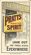
Anglo-American met strong competition from Shell, Royal Dutch and the Nobels in many markets, so to attract the growing number of motorists it commissioned a number of small format (6 x 3.5in) road atlases from George Philip & Son Ltd in 1904 & 1905, at a scale of around 8 miles to the inch. These had red with titles in the style South-eastern England for Motorists, Cyclists and Pedestrians; SE and SW England were followed by Northern England and Scotland in 1905. Up to three of the red volumes were bound into a red leather folder, which also had a pocket for the - newly introduced in 1904 - driving licence. In 1905, the three English sections were also issued bound as a single volume in light green cloth covers. This carried the [C]ycle Stores advert for the first time, but with the letters lacking red lining and reading "PRATT'S MOTOR SPIRIT", not "PRATT'S PERFECTION SPIRIT". A similar format Scotland and Ireland atlas in light green covers is dated 1907. All small format atlases show a head office address in Billiter Street; all medium format ones (below) show the later Queen Anne's Gate address. |

|
However 1905 a more commonly found pair of road atlases were produced, again by George Philip and Son, Ltd. These were hardbound in green cloth, and each had over 100 pages of full colour maps, including plans of large cities and road profiles. Sectional maps were now at 6 miles to the inch, with the profiles at 8 miles to the inch. These atlases have the unique distinction of being cited in the Oxford English Dictionary as being the first recorded instance of the phrase "Road Atlas". At the rear were 7 pages of monochrome adverts for Anglo-American's products. It is likely that these were reprinted with the same copyright date as the main advert appears to come in two versions: one on a "garage" (as shown below) and an earlier one at a "[c]ycle stores" (right). The earlier version also omits the "motor" before "spirit", and the cover states "POST FREE". |
|
|
|
|
|
The 1905 edition had on its frontispiece "Purveyors of Motor Spirit to H.M. The King By Royal Warrant". At the start of the maps section (twice in the Scotland & Ireland version) was a reminder to Look Out for these signs Everywhere. Only the cover was sadly dull, with black text on dark green cloth. |


Two further editions of the England & Wales and Scotland & Ireland atlases followed in 1914 and 1915, with the brighter cover featuring two gold Royal Warrants shown below and the name on the volume's spine for the first time. The first post war set does not appear to have been published until 1920:
|
|
|
|
The maps and road profiles (left) were essentially the same as in the 1905 edition. The colour rendering of the Pratt's sign shown above was still used, but the adverts at the rear had changed, to include this unusual one for Nujol anti-constipation pills, also made by Anglo-American! |


|
This is an undated set of strip maps that folds out concertina-fashion to reveal routes to and from the English Channel ports of Newhaven, Folkestone, Dover, Harwich and Southampton. The cover is printed in black on green cloth covered card with a single Royal warrant, apparently that of King George V, so it seems likely that they are younger the 1914 ones above which still shows the warrants for Edward VII and Queen Alexandra; most likely they were produced with the early 1920s battlefield tourists in mind. Two versions are known; one with a plain rear cover and one promoting Pratt's spirits. All text except for the cover was in English and French; scales bars were shown in both miles and kilomètres (sic). Each route was next to a contour map, with heights shown in feet and metres. The maps included symbols for golf courses, telegraph stations, garages and repairers. The footnotes provide motor vehicle carriage costs and the frequency of each sea route: surprisingly to a modern reader the Calais routes were for passengers only. |
|

Later in the 1920s, the apostrophe was dropped from to make the brand Pratts, and new editions of the atlases were created (although the frontispiece still said Copyright 1905, Revised 1929).
|
|
|
|
The 1929 cover now had gold and red lettering. The maps were again similar, but road profiles were omitted, presumably as cars had gained enough power to climb most British hills. The front advert now showed a service station that was more typical of California than England, and the rear adverts were in two colours, including this example for Pratts new Ethyl grade. |


|
The maps aimed at chauffeurs (and wealthy owner-drivers) were expensively produced. In contrast a map showing the location of "Filling Depots for Commercial Vehicles" is in light card covers and is mainly a booklet listing the addresses of Pratts' dealers. The map is at 40 miles to an inch and, unhelpfully shows no roads, except for London. Locations of Service Stations and Filling Stations are marked with a small red square or disc respectively. The booklet is undated, but the rear cover list motor racing successes up to 1928, so was presumably produced for the 1929 season, possibly as a cheaper companion to the final atlas above. Half tone photographs of three "typical Angloco service stations" are shown, but these are far from typical as they sold Pratts fuel exclusively unlike most petrol stations which sold up to 7 brands. |
|

No sheet maps are known from Pratt's or Pratts. Pratt's advertised on several other maps including the inside rear cover of Michelin maps from 1914 to 1920 (and was the only third party ever to do so on UK Michelin maps), and also advertised on a Tit-Bits map from 1930, given away with the popular magazine. A selection of these are shown on the adverts page.
Pratts was also well known for selling 'Pictorial Plans' in a variety of formats in the 1930s, and these are shown on a separate page.
Only one Pratts street directory is known from the Swedish operation.

Text and layout © Ian Byrne, 2000-13
All original copyrights in logos and map extracts and images are acknowledged and images are included on this site for identification purposes only.