Road maps from the former Yugoslavia |
Jugoslavia: 1918-41
Jugoslavia first became independent following the break up of the Austro-Hungarian empire, although the country name was only adopted in 1929. Poor, and ridden by competing factions, the impoverished country was outside the European mainstream. The small oil market was largely controlled by Shell and Standard, although there were some local names such as Motor-Oil of Maribor and Medjimurska of Zagreb.
|
|
|
Under the short dictatorship of King Alexander (1929-34) some efforts were made to establish a tourism industry. This 1933 map from the Automobilski Klub Kraljevine Jugoslavije features some 24 black & white photos adverts for hotels around a 1:1,500,000 map of the country. The reverse side carries mileage tables and information for motorists in 11 languages (including Russian, Turkish, Czech and Slovak). The English version includes advice that "Roads are fairly good and...the most out of the way places are safe". This side also carried adverts for ferry companies and three brands of oil: Socony (Standard Oil), Mobiloil (Vacuum) and Shell, which are all shown on the adverts page. |


Decentralised Communism: 1945-91
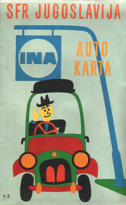
Tito's Communist partisans set up a new national oil company, Jugopetrol, two years after coming to power in 1945, having nationalised the downstream oil industry in 1946. Yugoslavia was held together through a combination of central control and semi-independent states, so in time each republic had its own national oil company and refinery. These were:
|
EP |
Energopetrol |
Bosnia-Herzegovina |
|
INA |
Industrija Nafte |
Croatia |
|
Istra Benz |
Istra-Benz |
Istria (Slovenia, also into Croatia) |
|
JP |
Jugopetrol |
Serbia |
|
JPK |
Jugopetrol Kotor |
Montenegro |
|
ΜΑΚΠΕΤΡΟΛ |
Makpetrol |
Macedonia |
|
NAP |
Naftagas |
Vojvodina (autonomous region of Serbia) |
|
PETROL |
Petrol Ljubljana |
Slovenia |
There was limited competition between the companies; INA in particular was found in most of the republics, and JP also spread outside Serbia.
After Yugoslavia disintegrated the republics took on very different natures and this is reflected in the oil sector. Croatia's INA had 200 of its 550 service stations expropriated (mainly in Serbia: these stations became the nucleus of the Beopetrol chain) and although 40 were later recovered (including those in Bosnia) most were badly war-damaged. Shell has announced plans to open 40-50 outlets in Croatia, and the Hungarian brand MOL had at least one before acquiring a 25% stake in INA.
Hellenic Petroleum (of Greece) has taken a controlling interest in Macedonia and Montenegro's petrol industies. Slovenia rapidly became the most stable of the new countries attracting several international oil companies; to preserve its status, PETROL worked for a while with the Austrian company OMV, but ended the link after its local rival IstraBenz set up a joint venture with OMV. Even in Serbia, NIS-Jugopetrol controls only 70% of the market from its 350 outlets, with the balance shared between Beopetrol (since acquired by Russia's Lukoil) and several smaller companies. Russia's Gazprom bought a controlling stake in NIS in 2008.
As might be expected, Energopetrol suffered most from the 1990s civil war and subsequent cantonisation of Bosnia; much reduced in size, it remains the largest brand in Muslim areas with 65 service stations. It is being privatised, but in 2005-6 the Government appeared to be trying to prevent highest bidder (a consortium of MOL and INA) taking control, possibly to limit INA's influence.
Maps: Domestic Issues
Slovenia
|
|
|
Slovenian maps are known from two domestic issuers before the break-up of Yugoslavia, and one afterwards. On the left are a 1976 PETROL map of its home state of Slovenia and a 1984 example of all of Yugoslavia. |
|


|
|
|
Istrabenz went into a joint venture with the Austrian OMV, which assumed full control in 2004, but the map shown here dates from 1996. Its modern cartography by Geodetski Zavod Slovenije marks all filling stations with a small red petrol pump symbol, but those selling OMV products have a green disc behind (compare the stations in Umag and Buje, both in neighbouring Croatia.) Unlike older Yugoslav maps, it does not give the Serbo-Croat place names for towns in Southern Austria, but does give Italian names for Istrian towns (such as Umago and Buie). |

")


|
|
|
|


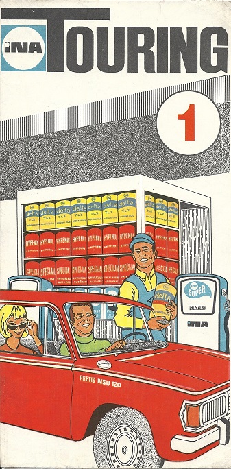
In the 1960s INA expanded into neighbouring Yugoslav republics more aggressively than its peers. The map shown left dates from around 1970 and at the scale of 1:750,000 shows how it already had numerous filling stations in all the republics except Montenegro and Macedonia. The second map is an undated sectional map that largely covers Slovenia; it shows only 3 INA locations in that republic, but many more close to the border inside Croatia. The car is a Pretis NSU 120, which was based on the NU Prinz and assembled in Sarajevo from roughly 1967-72. The next map was prepared by Avto-Moto Zveza Slovenije and probably dates from 1985. It is at the slightly smaller scale of 1:850,000 using a cartographic style similar to that used by Mairs of Germany and no longer marks any station locations. The simpler station locator map shown here (above right) is from the early 2000s with only limited detail. INA has moved into the orbit of the Hungarian MOL group since the break-up of Yugoslavia and lost most of its operations outside Croatia; its Serbian outlets were transferred to Beopetrol.
Most recent INA image courtesy Jon Roma
Serbia
|
|
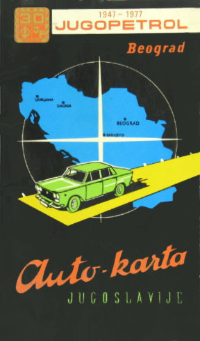
The Jugopetrol (Novi Sad) map shown left probably dates from the 1970s; among the car outlines there are some that can be identified as Western models such as the Mini or Citroen DS. The next map is clearly dated 1977 on the cover. |
|
 Jugopetrol map of Yugoslavia")


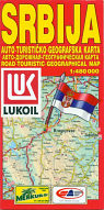
Serbia is still far from being a mainstream tourist destination, so it is not surprising that the National Tourism Organisation of Serbia turned to NIS, the main national petrol company to fund the tourist map of the country. The map shown here is its English version, of which 40,000 copies were printed, with the Serb edition only running to 10,000; MagicMap of Belgrade was responsible for the production. It is likely that other language versions also exist. Inside all main NIS stations with Evro-disel (diesel) are marked and listed by town. The rear cover, common to all language versions, shows a montage of NIS, NAP and Jugopetrol filling stations. NIS (Nafte Industrije Srbije) was formerly the national oil refinery and acquired control of the Jugopetrol chain in 1992. |
|
|
")

|
The map forms a 48-page booklet at the scale of 1:480,000, measures 4.5 x 9 inches and is in Serbian, Bulgarian and English, locating Lukoil stations on the map. An index inside also shows a Lukoil map of Belgrade. MontenegroThis map comes from Jugopetrol A.D. Kotor (JPK), the former national oil company of Montenegro. It was acquired by the Greek firm Hellenic Petroleum in 2002 and almost all its 39 service stations had been rebranded from JPK to Hellenic's EKO brand by the end of 2006. The map itself covers just Montenegro and is thought to date from the 1990s or early 2000s.Image courtesy Michal Okonek |
|

It is not known if other Yugoslav brands issued maps.
Maps: Cross-border Issues
International brands started including maps covering Yugoslavia in their map programmes in the 1960s and 70s although none of the six multi-national companies shown below was involved in petrol retailing in Yugoslavia at the time the maps were issued.
|
|
|
|
|
BP (1969, far left) and Caltex (1966, middle left) each dedicated an entire map to the country with Esso choosing to include it with Austria (1967, near left). Aral's Austrian arm sold two Freytag-Berndt sheets in custom card covers for 26Sch each in 1969. |


")
|
In the late 1950s Shell produced a Freytag-Berndt map of the country (not shown) but by 1970 had switched to a map of the entire Balkans (near right) produced by its regular cartographers, Mairs of Stuttgart. The most unlikely map shown here, however, is a Danish Q8 map from the early 1990s, probably printed after the country had already begun to disintegrate. Prepared by Cartographia of Budapest, it gives greater prominence to the internal national boundaries than the older maps. The copy shown here was still on sale at a Q8 garage in Ringkøbing, Denmark as late as August 2001, long after the Yugoslav federation had been broken up by war. |
|
|


|
|
|
After Yugoslavia collapsed into various civil wars in the 1990s, demand from tourists for maps disappeared. But with the return to peace, visitors started to return to the coast, including from the newly liberalised countries of Eastern Europe. Indeed, Slovenia and Croatia had become sufficiently popular destinations that Czech petrol companies added them into their map series. Shown here are a 2001 Aral map of the former Yugoslavia (described just as Slovenia on the spine) and a 2004 Shell map of the Croatian Coast (although including most of Slovenia, too). Aral's GeoMap (a trading name of Mairs of Stuttgart) was at 1:800,000, with Shell's edition prepared by Czech cartographer Shocart at 1:500,000. |


Text and layout © Ian Byrne, 1999-2020
All original copyrights in logos and map extracts and images are acknowledged and images are included on this site for identification purposes only.