Petrol Company Road Maps from Russia |
Maps from Soviet era Russia are shown in the lower half of this page.
As Russia fell under communist control earlier than other Eastern European countries, it is highly unlikely that any maps were produced by those companies operating there prior to the 1917 revolution. (Most such companies were only interested in extracting oil from the oil-fields in the Caucasus and would have had no retail operations.)
However during the 20s and 30s the Soviet Government became involved with a number of retail operations in European countries as it sought secure outlets for its oil, which the largest companies such as the "Standard" and Shell were generally reluctant to buy, preferring to develop their own sources. During this period companies such as R.O.P.-ZIP in England, Nafta in Sweden (later sold to Gulf), Victoria in Italy (later acquired by AGIP) and Derop in Germany (bought by BV-Aral in 1935) sold Russian Oil Products and road maps can be found from some of them.
After the war R.O.P. was sold to Regent and the Soviet Union stayed out of Western petrol markets until the 1960s when Nafta established chains in Britain and Belgium, took a controlling stake in Finland's TB (Teboil), and became an important supplier of oil to some Western firms such as Agip. By the late 1980s Nafta was in decline (with its British outlets sold to Q8) and Soviet influence appeared to be waning.
Post-1991 Russia
After the break-up of the Soviet Union in the early 1990s, there was an initial wave of interest by Western firms in the Russian downstream oil industry, that led to a small number of maps being issued carrying their logos:

|
One of the earliest post-Soviet maps covering part of Russia was issued by the Finnish company Neste in 1996. With the English title "From St Petersburg to Warsaw" it covered the Baltic states and NW Russia as well as Poland, marking Neste's new chain of service stations in the five countries. St Petersburg was included among the city maps (and is shown on the Neste page). The Mobil-sponsored sectional map (right) is to a scale of 1:750,000 and is number 7 from a series of 11 maps covering the Western half of Russia. Cartography was by Haupka. |

|
Since the break-up of the Soviet Union and the relative liberalisation of the Russian market, a number of new names have emerged into the retail petrol scene, often with strong local quasi-monopolies. Key names have included Lukoil, originally established in 1991 as Langespas-Urai-Kogalmneft, which has become the largest private sector firm and expanded aggressively internationally, initially buying chains such as Teboil in Finland and Avanti in Hungary. Lukoil has expanded into the US market (buying the Getty service station chain) and, working with its minority shareholder ConocoPhillips, bought their Jet chain in Belgium, Finland and Eastern Europe. The second key private sector player was TNK, which operated mainly through a joint venture with BP (and from which no maps are known). TNK-BP was sold to state-controlled Rosneft in 2013, but the downstream assets in Moscow remained under the BP and TNK brands; overall Rosneft is now the largest Russian oil company. Yukos was a third major independent name, but this ran into political and tax issues with the Russian authorities, and was dismembered in the mid 2000s, again with most of its assets going to the state-controlled Rosneft. The final main name is Gazpromneft, the oil arm of the state-controlled quasi-monopoly in natural gas, Gazprom. Despite this, there are still many smaller brand with strong regional marketing operations, and Shell maintains a substantial chain in Moscow.
|
|
|
|
|


Since the late 1990s, the preferred form of map for sponsorship by petrol and oil companies has taken the format of an atlas, often printed on relatively low quality glossy paper. Although I have not seen all the maps shown here in person, it appears that in most cases the petrol company was just one of several sponsors, usually also including a prestige motor car firm, and internally the atlases lacked customisation for the petrol company concerned, but did carry a number of generic adverts.
The four atlases above each cover Russia plus Belarus, Moldova, the Ukraine, and the three Baltic states. European Russia and the six former Soviet states are covered at a scale of 1:1,100,000, but Russia in Asia is at the small scale of 1:7,100,000. The atlas also includes an enlarged scale map of the Greater Moscow area. They were all sold by Argo Press, using cartography from Euro Atlas GmbH and the sponsorship was assembled by Atlas-Media. The earliest dates from 1995 and carries Shell's logo; as well as the red covered version green and blue versions were also produced in different years. The next two editions are both thought to date from around 2000; Lukoil's blue covered edition (ironically given that its corporate colours are red and white) features a BMW motor car and the Yukos edition a Mercedes. A Mercedes C-Class car is also shown on the cover of the youngest atlas shown, dating from 2002, again sponsored by Yukos, which also paid for the rear cover advert. Internally this atlas includes around 5 further pages of advertising in its 230 pages. Atlas-Media are known to have produced other atlases covering Moscow and Europe; it is likely that these similarly carried oil company sponsorship, possibly including BP.
|
|
|
|
The maps on these two rows come from Allmaps which uses a similar business model of selling cover advertising to several firms, and broadly come from the period 2000-4. The top row has three Lukoil issues; both Moscow issues show a BMW, but the Russian atlas has a Nissan X-Trail. Both larger format maps also advertise Bosch electrical parts. |
|
|
|
|
On the lower row, all three atlases are of St Petersburg. The first two feature PTK (TK), NW Russia's largest brand of petrol, and the final one from Phaeton (Faeton) another brand based in St Petersburg. None of these show cars on the front cover. |


I would like to thank Michal Okonek for providing me with scans of the Shell and Mobil maps, Dennis Frajevich for the allmaps images (Lukoil, Phaeton and PTK) and Maksim Bily for sourcing the Yukos atlas.
Soviet era maps
Although the Soviet Union discouraged private use of cars, with long waiting lists for the few models available, and the downstream oil industry was organised through a series of local or regional monopolies, a few maps were produced for domestic use that showed service station locations.

|
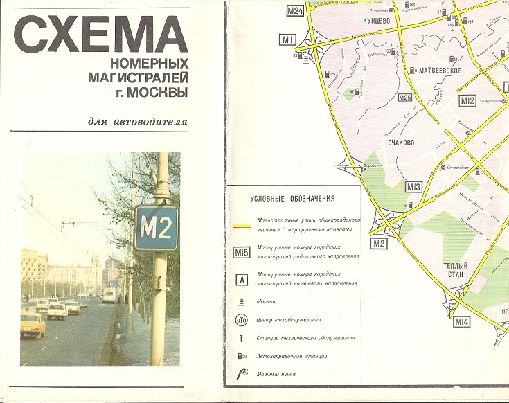
This October 1976 map is described as a Plan of numbered highways in Moscow for automotive care, but although the cover shows a highway number, the most useful feature is that is marks and numbers all 174 petrol stations - without providing a key. The map also shows a single car wash, a small number of repair garages and all metro stations, but these are not included in the legend. It appears that 1 million copies were printed. |
|
 |
 |
 |
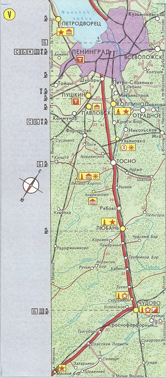
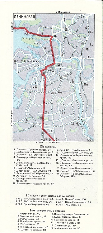
 In 1979 a strip map was produced showing the Automobile Route from Moscow to Leningrad and Vyborg; this was then reissued in October 1983, as shown here. The 24 page booklet contained six strip maps, each facing a short description of the towns passed through; city plans of Moscow, Kalinin and Novgorod showing hotels, petrol stations and repair garages; and a number of photographs such as a statue of Lenin (left). Only 10,400 copies of this booklet were printed.
All original copyrights in logos and map extracts and images are acknowledged and images are included on this site for identification purposes only.