 BP
BP
1955-1977 Maps: National Variations
BP maps in the period 1955-77 were subject to rather more variety than other companies with co-ordinated map programmes such as There are separate pages for BP maps from Germany and the United Kingdom, both of which sold extensive numbers of sectional maps.
Belgium & Luxembourg
Belgian maps from the 1950s conformed closely to standard designs, except for a special issue prepared to guide visitors to the 1958 Brussels World Fair. In the 1950s and early 1960s, it used a map at 1:320,000, pasted into card covers that followed the standard BP designs. The map was specially printed for BP and essentially used the same cartography, even though it was credited in turn to I.R.A., E. Stockmans & Co S.A., de Bièvre Brasschaat Typo & Offset, La Tournhoutoise and finally, after the card covers had been dropped, to de Bièvre Brasschaat again.
| The examples shown are all undated but believed to date (L-R) from around 1960, 1963 and 1968. The earliest was credited to La Tournhoutoise and the middle one to de Bièvre Brasschaat. When the contract passed to Cartographie Mercedes the map was redrawn at the smaller scale of 1:400,000, allowing it to fit onto a single side. None located BP stations. Earlier maps had to be flipped vertically between Northern and Southern sections, which was counter-intuitive as pasted into their covers; later ones more logically could be turned over horizontally. |
 |
 |
 |
France
 |
 |
 |
 |
|
In the 1950s, BP still stressed the name "Energic" in its French marketing, as on the folded booklet map shown far left. Produced by Blondel la Rougery, these were the standard format for BP maps of France until the late 1960s. However in 1960 a single sheet promotional issue was printed for BP by Déchaux; like all the booklets it located principal BP Touring station locations. |
|
 |
BP also published larger, 12 page grey covered folded booklets. Early ones broadly followed the international design guidance (although there were sometimes significant changes to the maps inside without changing the cover), but by around 1962 a plain grey cover had been adopted which bears a superficial similarity to much later BP covers. The Atlas des Routes de France also started off by Déchaux, but was later produced by Photolith L. Delaporte and by 1962 credited l'Institut Géographique National (IGN). The final map shown is a 64 page folded booklet of autoroutes, again highlighting BP locations, that was sold for Fr2,50 around 1969, quite probably at all motorway service areas (not just BP stations). This used SFREC for cartography, but was again based on IGN designs. |

Italy
 |
BP was a late entrant to the Italian petrol market, but soon started issuing interesting maps prepared for it by Istituto Geografico de Agostini of Novara (IGDA). National maps were at a scale of 1:1,000,000 (left from 1964) but more unusual were a series of 37 local maps at 1:300,000. The 1963 editions showed local landmarks (right), but the covers were more abstract for 1964-9 (far right), relegating the BP logo to the back. BP locations were marked in cities from 1967 onwards. |
 |
 |
|
|
The BP Touring Service, in conjunction with the Crociere linea shipping lines, produced this pocket-sized map of the Mediterranean in 1961. Looking much more like a typical atlas map than a road map, it was produced at the very small scale of 1:8 million by Istituto Geografico de Agostini, but with slightly larger scale inset maps of the Azores and Canaries. Printed on one side of the paper the map opens out to just 675mm by 295mm. The rear cover includes brief information about the BP Touring Service in four languages. |

Netherlands
 |
BP maps of the Netherlands are never dated. In the mid 1950s (left), two anonymous sheets covered the country at 1:400,000. By the mid 1960s, BP had moved to the widely used Bootsma/Falkplan cartography, with a single large sheet covering the country at 1:350,000. This basic map design was still in use, but at the larger scale of 1:250,000 and pasted into card covers, in the mid 1970s (far right). |
 |
 |
Norway
|
Norway was BP's oldest continental European market, and sometimes issued maps away from the main international style. These maps date from 1957 and 1959 respectively. Both cover the country at 1:1,000,000 by splitting it into three sections using a folding system similar to that of Foldex. The earlier example pastes the map inside into over-sized card covers, but the latter one is just on paper; the folding system meant that the corners were easily damaged. Using a relatively large scale allowed "all the larger and some of the smaller" BP stations to be marked, at a time when almost 1500 BP outlets served the 4 million Norwegians. |
 |
 |


|
 |
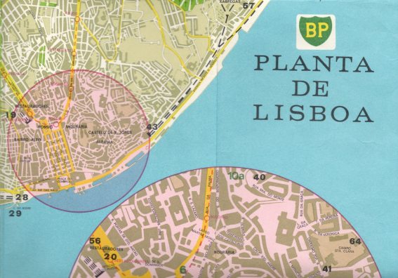
This 70-page guide & map to Lisbon was written by Sarah Bradford for BP and is based around what to see in one, two or three days. 10,000 copies of the second edition were printed by Orbis in 1970. The BP logo is extensively used in the English-only text. |
Sweden
 |
Sweden was one of BP's most important markets, and it issued this map in 1955. The cover clearly shows how Swedes still drove on the left side of the road at that time. The map was drawn by AB Kartlitografen at 1:1 million, and highlighted towns and villages with BP stations. BP also issued a separate sheet with town plans of Stockholm, Göteborg and Malmö. |
Switzerland
In the three German speaking countries of Europe, BP used a common name of BP Benzin and Petroleum AG.
") |
") |
The Swiss arm gave away a typical Kümmerley & Frey map (left) in 1960, backed by a list of BP stations selling Primus gas for campers, as well as a short list of motels. In 1964, BP issued a special Orell Füssli map of Lausanne (right) for the Swiss National Exhibition held there that summer. BP appears to have issued more city maps than other companies, co-producing a series of 9 plans with Swiss Bank UBS that included touring centres such as Bellinzona and Locarno as well as major cities. |
 |
After around 1977, BP appears to have given up any attempt to co-ordinate its map cover designs centrally, and for the relatively few maps that have been issued since 1978, almost any design seems to have been acceptable!

Text and layout © Ian Byrne, 2002-16
All original copyrights in logos and map extracts and images are acknowledged and images are included on this site for identification purposes only.