 French Predessors of TOTAL:
AZUR, AERO, OZO, STELLIS
The four brands shown on this page were all acquired by TOTAL in the late 1950s or early 1960s.
Azur (Desmarais Frères)
Brief History
Desmarais Frères was an independent French petrol and oil distributor established in 1861. Initially using the Automobiline name, Azur was introduced as the brand for supercarburants in 1932, and became the principal brand in 1950. Prior to the second World War Desmarais Frères was the third largest petrol distributor in the country. Lacking its own crude oil or refineries it acquired stakes in both the Compagnie Française de Pétroles (C.F.P.) and the Compagnie Française de Raffinage and was the largest single customer of both. In the mid 1950s, Desmarais Frères started introducing C.F.P's new TOTAL brand at selected sites; sometime between 1962 and 1966 the company was absorbed by C.F.P. (now Total) and the Azur name was finally eliminated from its 3,500 filling stations by 1970.
Maps
Azur specialised in small booklet maps which were primarily designed to locate their service stations.
|
|
Azur started issuing map booklets (Guide Azur) before the War, as can be seen from this 1936 example (left). |
|


|
|
The 1955 example (left) contained has a 67 page directory giving addresses of all Azur stations, including small black and white plans of 12 cities. There were 8 pages of fold-out maps in the middle and a larger fold-out plan of Paris inside the rear cover; the cartographer was anonymous. For 1956, the number of map pages was increased to 14, with three devoted to Paris and its suburbs. The page numbering was weird, with the maps inside the front cover, but numbered as if they were part of the main text, and the Azur location list placed out of sequence in the middle of the booklet. |
|


|
|
The 1958 Guide Azur retained 14 pages of maps, but the separately bound booklet had grown to 136 pages, now carrying on the numbering sequence from the maps. The increase in its size was due to sunstantially larger town plans with additonal cities such as Orleans and Perpignan being added. |
|


|
|
In 1960 (left), the booklet was again ring bound, but with a glossy card cover brightening the same night view. As in 1959, the complete station listing had gone, but there were now fold-out coloured plans of 44 cities and 12 pages of general maps (plus four of Paris). Station addresses are given on the city plans, but not for small-town or rural stations. |
|


Azur booklets are relatively hard to find in good condition, as the fold-out format seems to have been quite fragile. Azur also sold fuel in Madagascar and Mauritius, but no maps are known from those two markets.
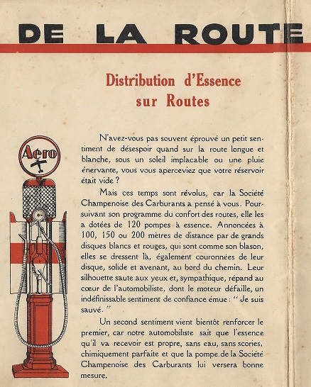
AERO
There have been a number of companies using the name "Aero" in Europe, but the three maps shown here come from Société Champenoise des Carburants. The later map gives full contact details for the firm as being Aero - Champenoise des carburants - Société anonyme au capital de 26.610.000 francs - 252 Avenue Jean-Jaures - Reims - Tel 54-81 - 54-82 - 42-93 - R.C. Reims 1.071. It is not known when the Aero brand was replaced by Total (probably before 1960), but the company was finally absorbed into CFP in a corporate reorganisation in 1968.
(Other companies using the name have included the Aero Petroleum Co of Barking, which sold Aero petrol in East Anglia and SE England and the California Motor Oil CY of France, which marketed Aero lubricants.)
|
This map is thought to date from the late 1920s or early 1930s and, typically for French maps of the era, is a plain map of the Champagne region at 1:2,000,000 inside a buff slip envelope. Unlike many such maps, the cover is finely illustrated, showing various Aéro products including a visible pump, a mobile AérOil dispenser, a warning road sign and a first aid post sponsored by the company. The slogan on the oil dispenser translates as "The best oil at the best price"; by the 1950s it became "Long life to your engine with Aero". |

|
|
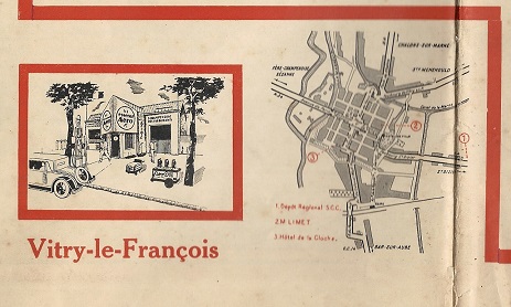
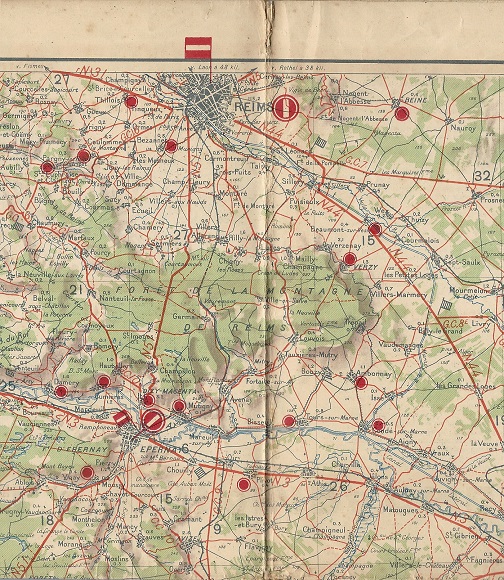
These images are taken from a map titled "Reims (Sud)" that is dated March 1930, produced for the company by EPOC using cartography by the Service Géographique de l'Armée at a scale of 1:200,000, similar to sectional maps sponsored by Shell/Dunlop. Unlike the other maps, the Aéro map marks all locations on the map, as well as devoting the entire rear side to information about the company, its locations and local towns. It would almost certainly also have originally been in an envelope. |
") | ||
")
 from 1930 Aero map of Reims (Sud)")
|
This map is undated, but thought to be from the 1950s, printed by "Publicited". The map is on heavy paper opening out to about 14 x 10.25 inches, and inside has a rudimentary map of NE France, encompassing its marketing area (which appears to have expanded East and West). The back panels list about 160 station locations. |
|
 Aero map of Champagne region")
 Aero map of Champagne region")
OZO (Omnium Française des Pétroles)
Brief History
OZO was the trading name of the Omnium Française des Pétroles (OFP) which was established to develop oil marketing activities mainly in Francophone countries, having assumed at least some of the assets of the old Steaua Romana company. It sold OZO branded petrol in France, Switzerland, Morocco, Sudan, East Africa and (through ICP) Italy. In 1954 it was one of the first independent franchisees to start using CFP's TOTAL brand and in 1960 CFP acquired OFP to prevent it falling under the influence of the newly-formed French rival Union Générale des Pétroles.
Maps
|
|
OZO maps are very uncommon. This 1956 Kümmerley & Frey map of Switzerland is the only one known of the country. The cover indicates (in the three main Swiss languages) that its depots and service stations are found throughout the country; the rear cover advertises its Champlin Motor Oil. 1950s photo of a French OZO station
|
|


|
|
|


OZO maps are also known from Italy.
Stellis (Stellane, Stelline)
Brief History
Lille, Bonnières et Colombes was established in 1877 and became one of a number of family controlled oil companies operating in France. One of the founding shareholders of the Compagnie Française de Raffinage in the 1920s, it was dependent on CFR for its petroleum products, and before the war appears to have used the Stellane name as its main brand of fuel. When CFP-CFR introduced its own distribution network in the 1950s, L-B&C's own outlets which were by then under the Stellis name (but mainly selling Stelline branded products) ceased to be viable as an independent chain. Consequently at the end of the 1950s Lille, Bonnières et Colombes sold its fuel operations to CFP and its service stations soon switched to the TOTAL name. The company stayed in business as an industrial holding firm until 1996, when - after a three-way merger - it changed its name to Fimalac.
Maps
|
|
Little is known about this small format Stellis map (left, taken from a low quality digital image). The undated (1950s?) Stelline map (right) covered just the NW part of France (excluding most of Brittany, presumably as the company did not market in that region) but is described as being "Sud-Ouest" (southwest). It used very basic anonymous cartography, but marked all towns with Stelline pumps by the logo, as well as listing their address. The most notable feature was a very large national mileage chart on the reverse. |
|

 Stelline map of Western France")
 Stelline map of Western France")

 Stelline map of Western France'))
Text and layout © Ian Byrne, 1999-2010
All original copyrights in logos and map extracts and images are acknowledged and images are included on this site for identification purposes only.