 AQUILA
Brief History
Aquila, the "gas judged by speedmeter", (la benzina che si giudica col contachilometri) was an Italian independent oil company, 15% owned by the FIAT Auto group, which built Italy's (then) largest oil refinery in Trieste in 1937. It was the fifth largest brand immediately prior to the Second World War with a 7.7% market share. There was also a small chain of Aquila filling stations in neighbouring Austria. In 1955 its thousand service stations were acquired by the Compagnie Française des Pétroles (Total) and although the name continued to be used for several years, by the mid-1960s it had been replaced by TOTAL.
Maps
 |
In the 1950s Aquila focused on atlases of Italy. Left dates from 1956 and has 22 pages of maps in a plastic comb binding. Right was sold in 1958 and has thick card covers and a wire spiral binding. It has 32 pages listing service stations with facilities followed by a 23 page map section. Both use cartography was by Istituto Geografico de Agostini (Novara), and neither mark service stations on the maps themselves. |
 |
 |
 |
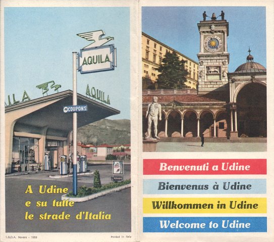
The front covers (left) of these quite small Aquila city maps from 1958-61 carried no branding, but a photo of a local landmark or festival. Inside were more photos plus a city plan and regional map showing service station locations. As well as the largest cities, smaller ones such as Bergamo, Siena and Udine were included in the series. The common rear cover design from 1958-9 (right) showed a typical filling station. |
 |
 |
By 1960, Aquila had moved to lower cost sheet maps. The 1962 map of Italy (left) must be one of the last prepared for the brand: note how the cover promotes coupons allowing foreign tourists to buy petrol at a favourable rate. Internally, it is a typical IGDA map at 1:1,000,000. |

|
|
Aquila's Austrian chain also issued at least one map. The example shown here (right) was used in 1960 and 1961 with anonymous cartography. It also includes Southern Germany and Northern Italy, with the reverse devoted to small plans of major Austrian towns plus Mailand (Milan), Triest (Trieste) and Venedig (Venice). Many Austrian Aquila stations were supplied by Rumwolf, and so switched to Total but were eventually sold to OMV. |
 |

Text and layout © Ian Byrne, 2000-15
All original copyrights in logos and map extracts and images are acknowledged and images are included on this site for identification purposes only.