AGROLA
Brief History
Foreign visitors to Switzerland might be forgiven for not noticing the Agrola brand at Swiss petrol stations, as they are often in smaller towns and villages attached to Landi farmer's supply warehouses. In fact Agrola has one of the most extensive retail petrol chains in the country and is by far the largest petrol brand in Europe controlled by the agricultural co-operative sector, in this case the Swiss Fenaco co-op. Agrola started operations in 1956 under the Agrol name, and in 1957 changed to Agrola; by the mid 1960s its green and yellow pumps were becoming more common, and by the mid-1980s it had over 400 outlets. A loyal customer base and strength in out of the way locations has enabled it to close fewer sites than its big international competitors, so that around 425 filling stations remain in operation today, mainly in German speaking areas. Like other agricultural co-ops in Europe, Agrola was a pioneer the introduction of bio-diesel and is also involved with other consumer-focused forms of renewable energy such as PV and wood pellets.
Maps:
|
|
The oldest known Agrola map is from as far back as 1962, when the chain would still have been quite small. Unusually, it shares a cover photograph (of a rather clichéd scene with a young girl and mountain cattle) with the Gulf map from 1958, but it is likely that it was simply a stock image from the cartographer Kümmerley & Frey rather than implying any relationship between the two petrol companies. |
|
|
|
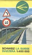
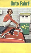
The next known map dates from 1968 and was printed for Agrola by Kümmerley & Frey at a relatively generous scale of 1:400,000 (approx. 6.3 miles top the inch). The front cover shows the newly built South side of the St. Gotthard pass, and the rear a rather clichéd picture; note how the Agrola pump is in front of a plain breezeblock wall, not in a modern service station! |
|
Maps are equally uncommon from petrol stations associated other European agricultural co-ops. This site has an example from Austria's Genol, but none are known from the German Raiffeisen, or Bavaria's BayWa. It is highly unlikely that smaller co-ops such as Agrol (Sweden) or ECF, WCF or MSF (Britain) have ever had their own road maps.
Text and layout © Ian Byrne, 2003-15
All original copyrights in logos and map extracts and images are acknowledged and images are included on this site for identification purposes only.


