 Errors on road maps(2)
Many maps contain small errors; sometimes deliberate to help protect copyright (and trap others making copies) and sometimes inadvertent. This page will look in some depth at a few of the more interesting errors on maps.
A map with many small errors
The map shown below is an extract from a map of Europe backing a ca1961 Mobil map of Greece, prepared locally by Geometrographic Institute of Greece "Pujol".
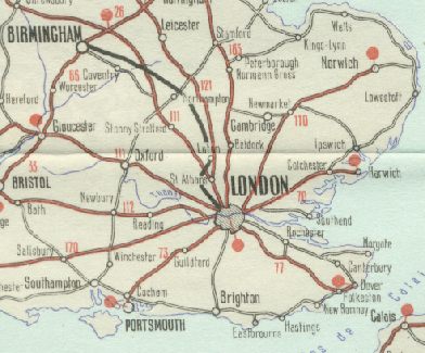
It's hard to know where to start in listing the errors on this map. Five place names are misspelled:
- Stonny Stratford for Stony Stratford
- Normann Cross for Norman Cross (a road junction S. of Peterborough)
- Eastbrourne for Eastbourne
- Folkeston for Folkestone
- Cocham for Cosham (N. of Portsmouth)
The coast is clearly hand-drawn, resulting in a rather odd shape to the Isle of Wight, but it's just about acceptable, even if the Isle of Purbeck and Portland have been merged into a single peninsula. The positioning of the M1 is not: it passes to the wrong side of Northampton then sweeps into the centre of Birmingham. At first glance this would be acceptable for the M6, but the map was created before that motorway was built; it should show the motorway passing SW of Northampton, then ending just before Coventry on what is today the M45 spur. The M50 is missing completely, as is the Preston bypass (M6) further North (off the extract). Distances are in miles, although the legend says that they are in kilometres, without distinguishing those in the UK/Eire.
Adding a fictitious village as a deliberate error
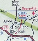 An example of a deliberate error from outside the UK was revealed at the 2002 meeting of the Road Map Collectors' Association. Frank Brown, a former official at the Big Three US commercial mapmakers (Rand McNally, Gousha and General Drafting Co.) was asked about the practice of introducing errors to maps to protect copyrights, known as "key traps".
He told about a trip by General Drafting founder Otto G. Lindberg and his assistant, Ernest Alpers, in the New York Catskill Mountains. They came across a deserted dirt road intersection north of Roscoe, NY and decided to scramble their initials and name it "Agloe" as a key trap on the Esso maps. Years later they found Agloe on a Rand McNally map of New York state, and approached their competitor. Rand checked their sources and found it came from the county. Apparently someone built a general store at the intersection and called it Agloe because that's what it was marked as on the Esso map.
Agloe appeared on Esso maps in the 1930s, and was still there on the last American Map issue of New York state for Exxon in 1998. Note how the dirt road has become State Highway 206.
![]()

All original copyrights in logos and map extracts and images are acknowledged and images are included on this site for identification purposes only.