 Diesel and Truck facility maps
This page will look at both maps produced to promote filling stations selling diesel fuel and maps - or booklet guides - aimed at long distance lorry drivers (truckers) showing where there were special facilities for them. It will not include ordinary maps that identify diesel fuel as being one of the grades available in service station lists.
The first compression-ignition engine was patented by Rudolf Diesel in 1892, and prototypes were built soon after. However the high temperatures and pressures meant that they were difficult to manufacture and it was not until 1923 that Daimler-Benz built the first diesel-engined lorry. Over the next decade they started to appear on European roads and larger service stations began to add an extra pump for the fuel oil that soon became known as diesel or gasoil. (In Britain it was named DERV, from diesel engined road vehicle and other national terms included the French gazole and Italian gasolio.) However it remained a relatively uncommon fuel before the war, when its greater economy was appreciated for use in trucks and fighting vehicles.
Diesel Fuel maps
|
|
|
|
Click to enlarge |


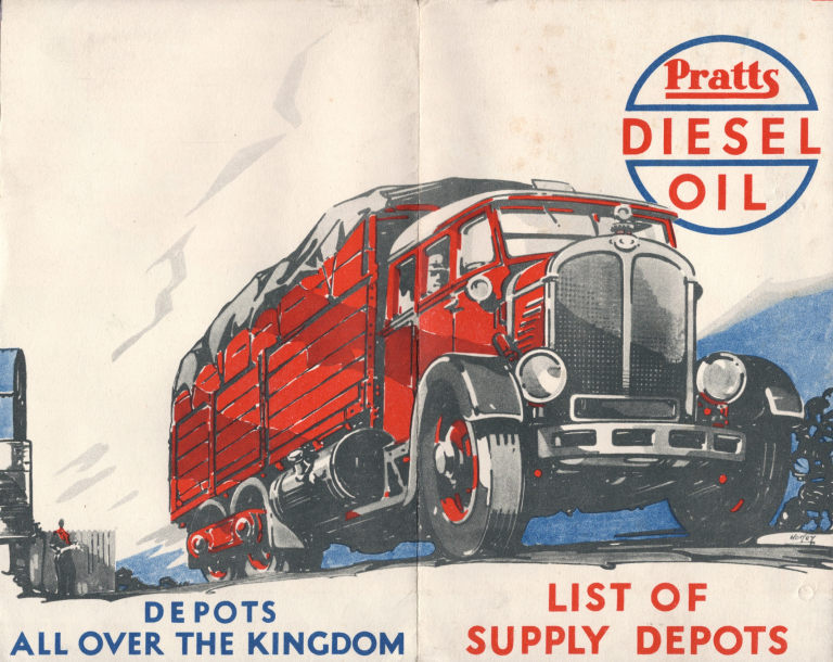
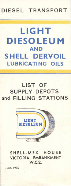
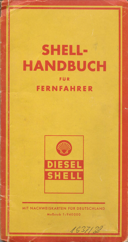
The four maps above all date from the 1930s. The first three are from Britain: a Pratts from the early 1930s, an Essodiesel from the mid to late 1930s and a Shell-BP from 1935. All are quite basic maps showing only towns with depots or filling stations selling diesel fuel. Extracts from these three maps (and covers of a couple more Essodiesel and Shell-BP maps) are shown on the page devoted to 1930s British diesel maps. The final map is a much more sophisticated production from Germany described as a Shell Handbuch für Fernfahrer. This is a small atlas containing 14 pages of fold-out maps at 1:940,000, preceded by a lubrication chart, several pages on which to keep a record of fuel purchases and calendars for 1937 & 1938. A 16 page booklet listing all Shell diesel sites fits into a slip pocket inside the front cover. In contrast the British maps are all able to list the complete diesel network for their respective brands on one side of the map.
 |
 |
 |
 |
 |
The five maps above represent a good cross-section of the small number of diesel sheet maps known. The first, dating from around 1953, is of West Germany at 1:1,000,000, and lists all BV stations selling diesel - the main brand Aral was only used for petrol (gasoline) grades. The next map is a normal Shell map of Italy produced by its regular cartographer, Agostini. However unlike normal maps it is pasted into a wipe clean cover, with commercial vehicles shown where there would be Italian landmarks, and the rear and insides of the cover carry adverts for Shell's Rotella oil for diesel engines. It does not list diesel sales points.
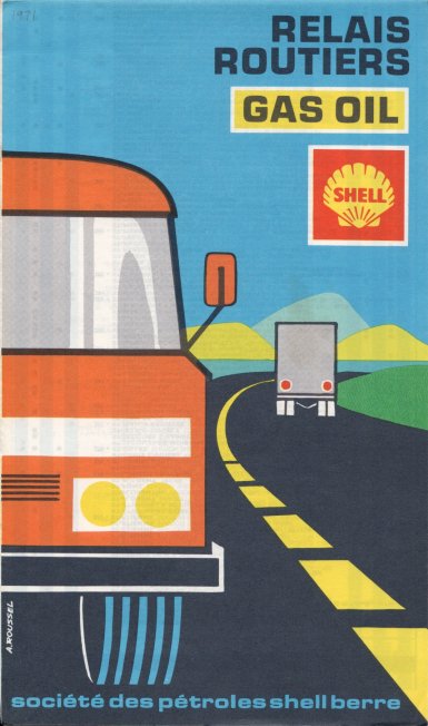
The remaining three maps are from France, the country where diesel has been most readily accepted by car users as well as trucks and buses, partly due to a wide tax differential making it much cheaper than petrol. However the first two, called Relais Routiers, are still clearly aimed at lorry drivers; both are from Shell and designed to complement their cartoguides for private motorists. The earlier example is dated 1960 and the latter 1971 (click to enlarge); both list diesel sites and identify those open day and night. The final map - from 1978 - does not say on the cover that it is aimed solely at diesel users, although the "gasoil" under the BP sign is quite prominent. However inside, BP diesel locations are marked on the Recta-Foldex map with a black shield, and all diesel stations are listed on the reverse.
 Maps aimed at Truck Drivers
Although long-distance deliveries by lorry have existed for many years, road freight was relatively limited compared with that on trains until the 1950s. With the beginning of easier trade across national borders in the European Coal and Steel Community in the 1950s leading inexorably to the European Union's single internal market for goods in the 1990s, international trucking became much more widespread.
However truck drivers needed to know where to refuel their vehicles, as well as where they might find a place to eat. So in the past 25 years or so, one of the few remaining types of maps sponsored by oil companies have been those aimed at long distance truck drivers. Many of these maps are not widely distributed but sent only to holders of oil company payment cards: the maps shown in this section are therefore only a small selection of those that may be available. |

|

|

|

|

|
In order to allow better coverage of Europe, the larger companies entered into a number of loose alliances based around payment cards. In the early 1990s, BP, Aral, Mobil and Agip's domestic Italian subsidiary IP formed a grouping called Routex. Over the next decade, BP acquired first Mobil and then Aral's networks, effectively bring Routex under its more direct control. BP's Truckers' guide from 1995 has rudimentary maps showing BP Truck Stops near main highways, but not those of its partners. It also has a small-scale fold out map of the whole of Europe pasted into the rear cover.
In contrast Mobil's 1993 International Driver Directory shows truck-friendly sites from all four brands, plus selected additional sites in Spain. Its 320 pages include 24 double pages of maps, as well as detailed site listings and space for drivers' notes. The directory was prepared by Agostini in Italy and came with a small supplementary volume listing sites in countries omitted in the main book - mainly those in Scandinavia, Eastern Europe and Gibraltar.
AS24 is the brand name used by Total on its, generally unmanned, dedicated fuelling points for commercial vehicles. AS24 is found at over 300 locations in 14 European countries (although there is only a single site in each of Belarus, Ireland and Portugal). Their sites are often located on the edge of industrial zones, or more rarely at conventional service stations (many of which are independently branded, not in the Total group). The 304 page guide contains instructions on how to use AS24 pumps in 12 languages, with detailed access and small locator maps for each outlet. The guide ends with 8 pages of small scale maps covering most of Europe prepared by Gabelli, Paris.
Total also published a small format atlas of France with 132 pages of high quality maps and a full listing of stations taking GR (Grand Routier) cards aim at commercial vehicles. This was sold for 25Fr at selected Total stations in 1999.
Among other companies, Esso is also known to have published an A5 format map/directory listing its truck filling stations.
Possibly produced by Shell's Dutch arm, a 1991 atlas (right) was produced for free distribution to truckers holding euroShell payment cards. 26 A4 map pages showed euroShell locations on quite basic maps of each country, opposite an address list. Most countries were on a single page, (including Belgium & Luxembourg twice) and Eastern Europe was well covered, even when euroShell service was only available through local brands such as Benzina or Istrabenz. |

|

|
An undated Eurotrafic atlas was issued by TotalFinaElf (above right) around 2002. The front cover shows all three logos, although in the station listings Fina has been eliminated from France & Germany, Elf from Belgium and both from the Netherlands (and almost from the UK). Geosignal provided clear, but basic, mapping of most of Europe at 1:1,000,000, with a slightly larger scale in Benelux, and smaller in Southern Scandinavia and Morocco. At the rear some 6,000 locations from the three main brands plus partners are included, representing around half the sites accepting the Eurotrafic card, and the most suitable for trucks. Partner brands include Cepsa (Spain), Westfalen, SVG and Lomo/DEA (Germany), dcb (Netherlands) and ERG in Italy. Scandinavia is not well covered, with just a handful of Shell stations in Norway and Q8's IDS truck sites in Denmark & Sweden.
![]()

All original copyrights in logos and map extracts and images are acknowledged and images are included on this site for identification purposes only.