Petrol Company Road Maps from Morocco |
Morocco was independent until 1912, when it was divided into Spanish and French protectorates, with the area around Tangiers under international control from 1923. These three areas were reunited into an independent kingdom in 1956, since when the country has grown greatly in population, with moderate economic success. Lacking significant oil or gas reserves, the country has always been dependent on imported energy, although in recent years it has been investigating solar energy as an alternative source.
Its downstream oil industry was therefore inevitably controlled mainly by the international majors, in the French and international sections at least, with Shell, Esso, Mobil, Total and BP being present. The Spanish sector appears to have operated under a Government monopoly, as in mainland Spain, until reunification in 1956 allowed the major brands to enter the market. Some domestic brands started over the next 20 years, including Afriquia in 1959.
In 1974, the Moroccan Government started a process of "Moroccanisation" which included the state-owned Société Marocaine des Produits Petroliers (SNPP) acquiring a 50% interest in all petrol distribution companies and appointing an all Moroccan Board of Directors. Not all the international firms accepted this, but Shell, Total and Mobil did, and were allowed - along with indigenous firms - to repurchase the Government's stake in 1994 under a process of market liberalisation. The three largest companies in the market today are Shell, Total and Afriquia (which merged with Somepi in 2005). Other companies active in the market include Oilibya - which acquired Mobil's 182 outlets around 2009, CMH which was formed from the merger of BP and Agip in 1974 and introduced its own brand in 1994, Petrom, SOMAP, Ziz and Atlas Sahara. In all there are around 1,400 filling stations supplied by two oil refineries.
Maps
No maps issued by oil companies are known from before the Second World War, other than the Shell of North Africa shown on the Algeria page.
|
|
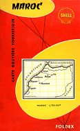
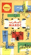
Shell has been a market leader in Morocco since the first filling stations were opened. A 1950s map from Foldex follows the European model quite closely (far left), except for a more graphic cover. The next known design (near left), while slightly different in background colour, also follows its European counterparts, with line drawings of local scenes. This map does however locate Shell stations. |
|
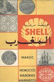
A slightly later map (above right) issued in the early 1960s, like its contemporary French maps, was described as a "Cartoguide", as the reverse of the map was given over to short descriptions of almost all towns and villages that had Shell stations (which were also marked on the map with a Shell logo). Cartography was by Bernard Rouget, and the map was printed locally on poor quality paper. |
|
|
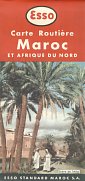
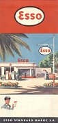
Esso was a significant player in the Moroccan market prior to its partial nationalisation. The map shown here is dated 1953 and was prepared and printed in France by Blondel la Rougery, to designs created by General Drafting Co. One side had a map of the country at 1:2,000,000 with the reverse showing the three Maghreb countries at 1:4,000,000, including thumbnail sketches of main points of interest on the map, similar to those on Esso maps elsewhere. Motorists planning a journey in North Africa were advised to write to the Esso Touring Service in Paris for route information. The front cover shows a Scène de l'Atlas and the rear cover, common to Esso maps from all three countries, shows an idealised Esso station with palm trees. |
Mobil has been active in Morocco for over 50 years, and is still used by ExxonMobil on Moroccan petrol stations. |
|||
|
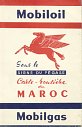
The first map shown here dates from 1955 and is unusual for the era in listing all 57 Mobilgas stations in Morocco. The list also shows that it only sold branded fuel in the French sector and Tangiers. The map was prepared by the French firm of Blondel la Rougery at a scale of 1:1,250,000. |
|
|
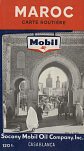
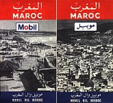
Later maps, from when Mobil was active across the entire country, conform more closely to the standard international style. The first example is based on a 1956 base map, and around ten years later Mobil used both the Roman and Arabic script versions of its logo on the covers, reflecting the reduction in French influence after independence. |
|||
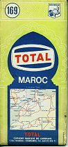 |
Total's origins in Morocco go back to 1926 when the Compagnie Marocaine de Carburants was formed. In 1951 it was acquired by CFP and in 1954 became one of the first networks to switch to the new Total brand, expanding in 1964 by buying Omnium Marocain des Pétroles (OZO). |
|
|
BP and Texaco are two companies that have withdrawn from the Moroccan market. |
|
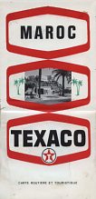
The cover design of this Texaco Maroc map of 1972 has a kinship with US maps of the same era. Internally the map was drawn by G. Debureau and located Texaco stations.
Texaco image courtesy Richard Horwitz
It is not known whether other petrol companies, including Afriquia and any of the more recent entrants to the market have issued maps. If you have a map from one of these companies, or could send me a scan of such a map, or - better still - the map itself, then please send me an e-mail!

Text and layout © Ian Byrne, 2006-8
All original copyrights in logos and map extracts and images are acknowledged and images are included on this site for identification purposes only.