Petrol Company Road Maps from Poland |
Prior to 1945
|
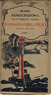
Although Poland had relatively few private motorists between the wars, some branded maps were issued prior to 1939. The two examples shown here are an early Standard-Nobel map of the Republic of Poland which came in four separate sheets (this is sheet one). From the visible pump and the use of a five-star Standard logo on the globe, this map may date from the late 1920s, which would make it amongst the very earliest petrol company maps known of Europe. |
|
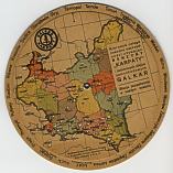
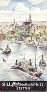
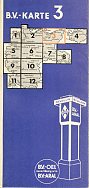
| The distance calculator (above right) came from GALKAR, which sold petrol under the "KARPATY" brand. The various Polish provinces are marked by different colours, and by rotating the lower card until the arrow pointed at the city name, the distance in kilometres could be found next to each main city (which included Berlin and Prague). No roads were included on the map, although rivers were shown! In contrast, maps from Pomerania, Silesia and East Prussia (the parts of Germany that were returned to Poland in 1945) are relatively common. The two examples shown here are a 1938 Shell map of the city of Stettin (now Szczecin) and a 1937 BV-Aral sheet covering much of Pomerania, which shows the German transit routes across Poland to East Prussia. |
|
Under the Communists
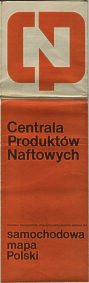 |
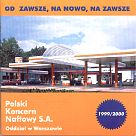
Between 1945 and the early 1990s, under the communist government, all Polish petrol was sold through the CPN monopoly. Although maps can be found in CPN colours (left), it is more common to come across tourist maps such as the one (right) published in 1985 for the state travel agent ORBIS. All service station locations were marked on the map, distinguishing between those selling 78 and 94 octane fuel. (Western European stations generally sold fuel at octane rating of 89 to 98 in 1985, and unleaded was beginning to appear in Germany.) Cartography on both was by the hard to pronounce (for non-Polish speakers!) Panstwowe Przedsiebiorstwo Wydawnictw Kartograficznych which translates as 'State Cartographic Publishing House'. After 1990, both Western and domestic companies started challenging the former state monopoly, now renamed PKN (Polski Koncern Naftowy). The map booklet of Warsaw (bottom right) was prepared by PPWK on cheap paper for PKN, and the maps still showed all service stations, irrespective of brand. |
|
Post 1990 issues
 |
 |
 |
 |
|
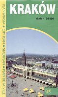
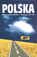
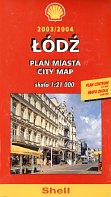
Other brands have also started issuing maps including Aral (which has since been sold to BP), BP itself - which issued several city maps as well as a national map of Poland, and Jet, which issued both a sheet map and a spiral bound atlas. Shell sells large scale city maps of 33 Polish cities including Lodz, at 1:21,000. All four maps above have cartography by Daunpol, one of the new independent cartographers that have sprung up, and locate service stations irrespective of brand. |
 |
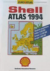 |
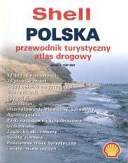
As one of the earliest and largest new entrants to the market, Shell has now issued road atlases for more than a decade. On the left is one of the first commercial hardback atlases of Poland at 1:300,000 with Europe at 1:800,000, published by GeoCenter International, Warszawa (an affiliate of Shell's standard German cartographer, Mairs). Ten years later, it was branding a Daunpol spiral atlas with fold over covers. Also at 1:300,000, each double page spread showed 5 photographs of points of interest. |
 |
 |
 |
 |
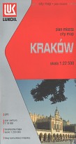 |
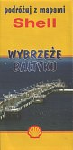
BP continued to issue maps of Poland (and several cities) as late as 2001, using the new sunflower logo, but now appear to have ceased issuing maps. The example shown above is a 112 page street atlas of Warsaw, produced for BP by Daunpol in 2000. Only the covers were customised for the company, and the inside front cover included a rudimentary map of the city showing the nine BP locations. After BP stopped issuing sheet maps, this left only Shell and Jet with a broad programme, both issuing an extensive series of Daunpol maps and atlases in card covers. However the Shell map above was a special issue covering the Baltic Coast (Wybrzeze Baltiyku), with the map stretching across both sides, in each case above a small gazetteer section; unlike the regular Daunpol issues this map marked towns with Shell stations. Like Shell, Jet included a number of medium sized cities in its series - the map of Bielsko-Biala here was at 1:20,000 and also included a district map and town plan of Zywiec. The rear cover showed the locations of Jet service stations in the city. After ConocoPhillips sold its Eastern European operations to Lukoil in 2007, it was thought that the new owners might abandon maps. However during 2008 Lukoil maps appeared, again using custom card covers over stock Daunpol sheet maps (some of which therefore carried a 2007 edition date inside). The Krakow map shown here is dated 2008; smaller cities are more likely to carry an earlier year as maps are updated less often.
I would like to thank Michal Okonek of map1 for providing me with scans of the Standard, Galkar and CPN maps, and for sourcing several of the post-1990 maps for me. The 1994 Shell atlas is courtesy of Wilhelm Feuer.

Text and layout © Ian Byrne, 2000-9
All original copyrights in logos and map extracts and images are acknowledged and images are included on this site for identification purposes only.